IMAGES TAKEN NEAR TO
White Street, GLASGOW, G11 5RP
Introduction
This page details the photographs taken nearby to White Street, G11 5RP by members of the Geograph project.
The Geograph project started in 2005 with the aim of publishing, organising and preserving representative images for every square kilometre of Great Britain, Ireland and the Isle of Man.

There are currently over 7.5m images from over14,400 individuals and you can help contribute to the project by visiting https://www.geograph.org.uk
Image Map
Images are licensed for reuse under creativecommons.org/licenses/by-sa/2.0
Notes
- Clicking on the map will re-center to the selected point.
- The higher the marker number, the further away the image location is from the centre of the postcode.
Image Listing (398 Images Found)
Images are licensed for reuse under creativecommons.org/licenses/by-sa/2.0
Image
Details
Distance
1
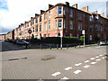
White Street at Ellie Street
White Street is on the left.
Image: © Thomas Nugent
Taken: 19 Mar 2017
0.02 miles
2
Sculptured relief on Ellie Street
One of several which depict local scenes on a fairly modern block of flats on the lower part of the street. This one is above No 3 Image
Image: © Thomas Nugent
Taken: 19 Mar 2017
0.04 miles
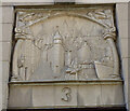
3
Sculptured relief on Ellie Street
One of several which depict local scenes on a fairly modern block of flats on the lower part of the street. This one is above No 3 Image
Image: © Thomas Nugent
Taken: 19 Mar 2017
0.04 miles
4
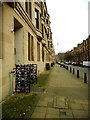
Lawrence Street
Terraced houses, each with a small front garden
Image: © David Smith
Taken: 19 Jul 2017
0.04 miles
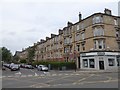
5
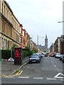
White Street
Viewed from Hyndland Street. Glasgow University tower Image is visible in the distance.
Image: © Thomas Nugent
Taken: 20 Oct 2007
0.05 miles
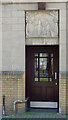
6
Lawst Coffee Shop, 18 Lawrence Street
Once a grocery shop of BS Padda & Co, the old signage has been retained.
Image: © Mark Anderson
Taken: 26 Jun 2019
0.05 miles
7
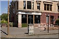
Chancellor Street
Bollards and distinctive metal entrance grills.
Image: © Richard Sutcliffe
Taken: 19 Feb 2019
0.05 miles
8
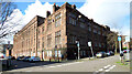
Former St Peter's RC School
At the corner of Chancellor Street (on left) and Dowanhill Street. The school closed in 2013 when it merged with the nearby Notre Dame Primary School. The building was demolished in late 2017 to make way for a housing development.
Image: © Thomas Nugent
Taken: 19 Mar 2017
0.06 miles
9

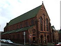
Dowanhill Free Church of Scotland
Category C listed church [http://portal.historicenvironment.scot/designation/LB50182] built in 1880.
Image: © Richard Sutcliffe
Taken: 19 Feb 2019
0.07 miles
10
St Peter's RC Church
On Hyndland Street. See the adjoining church house here Image
Image: © Thomas Nugent
Taken: 20 Oct 2007
0.08 miles