IMAGES TAKEN NEAR TO
Fordyce Street, GLASGOW, G11 5PH
Introduction
This page details the photographs taken nearby to Fordyce Street, G11 5PH by members of the Geograph project.
The Geograph project started in 2005 with the aim of publishing, organising and preserving representative images for every square kilometre of Great Britain, Ireland and the Isle of Man.

There are currently over 7.5m images from over14,400 individuals and you can help contribute to the project by visiting https://www.geograph.org.uk
Image Map
Images are licensed for reuse under creativecommons.org/licenses/by-sa/2.0
Notes
- Clicking on the map will re-center to the selected point.
- The higher the marker number, the further away the image location is from the centre of the postcode.
Image Listing (424 Images Found)
Images are licensed for reuse under creativecommons.org/licenses/by-sa/2.0
Image
Details
Distance
1
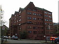
Former school
On Stewartville Street, now converted to flats. See some detail here Image
Image: © Thomas Nugent
Taken: 20 Oct 2007
0.02 miles
2
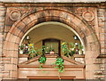
Ornate arch on former school
Ornate arch on the former school on Stewartville Street Image
Image: © Thomas Nugent
Taken: 20 Oct 2007
0.02 miles
3
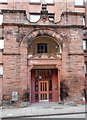
Entrance, former St Peter's Boys School
Former Catholic Primary School on Stewartville Street. The date above the door is 1890. The school closed in 2009 and was converted into flats. Its most famous pupil was Billy Connolly.
Image: © Richard Sutcliffe
Taken: 24 Aug 2018
0.03 miles

5
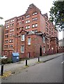
Former St Peter's Boys School
Former Catholic Primary School on Stewartville Street, which closed in 2009 and was converted into flats. Its most famous pupil was Billy Connolly.
Image: © Richard Sutcliffe
Taken: 24 Aug 2018
0.04 miles
6
Former St Peter's Boys School
Former Catholic Primary School on Stewartville Street, which closed in 2009 and was converted into flats. Its most famous pupil was Billy Connolly.
Image: © Richard Sutcliffe
Taken: 24 Aug 2018
0.04 miles
7
Hyndland Street
Viewed from mansfield Park.
Image: © Thomas Nugent
Taken: 19 Mar 2017
0.05 miles
8
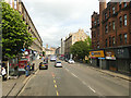
Dumbarton Road, Partick, heading east
From the top deck of a bus heading towards the city centre.
Image: © Stephen Craven
Taken: 25 Jun 2019
0.06 miles
9
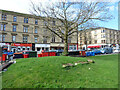
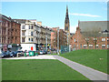
Mansfield Park
Hyndland Street is on the left.
Image: © Thomas Nugent
Taken: 19 Mar 2017
0.06 miles
10
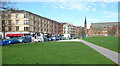
Mansfield Park
Looking towards Hyndland Street and the spire of the former Dowanhill Church, which is now a restaurant and theatre.
Theatre web Site: https://cottiers.com/ .
Image: © Thomas Nugent
Taken: 19 Mar 2017
0.06 miles