
IMAGES TAKEN NEAR TO
Dock Street, FLEETWOOD, FY7 6JW
Introduction
This page details the photographs taken nearby to Dock Street, FY7 6JW by members of the Geograph project.
The Geograph project started in 2005 with the aim of publishing, organising and preserving representative images for every square kilometre of Great Britain, Ireland and the Isle of Man.

There are currently over 7.5m images from over14,400 individuals and you can help contribute to the project by visiting https://www.geograph.org.uk
Image Map
Images are licensed for reuse under creativecommons.org/licenses/by-sa/2.0
Notes
- Clicking on the map will re-center to the selected point.
- The higher the marker number, the further away the image location is from the centre of the postcode.
Image Listing (227 Images Found)
Images are licensed for reuse under creativecommons.org/licenses/by-sa/2.0
Image
Details
Distance
2
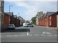
Church Street in Fleetwood, Lancashire
Image: © James Denham
Taken: 24 Jun 2014
0.02 miles
3
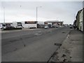
Fleetwood 2nd railway station (site), Lancashire
Opened in 1851 by the Preston & Wyre Joint Railway (joint between the Lancashire & Yorkshire Railway and the London & North Western Railway), this station replaced a nearby 1840 station, out of view to the left. This one was called "Fleetwood Dock Street" station between 1862 an 1876. In turn, it closed in 1883 when it was replaced by a larger station adjacent to the ferry terminal, several hundred metres behind the camera position.
View south west from Dock Street. No trace remains - the railway disappeared from here in the 1960s and the old station site is now occupied by retail outlets.
Image: © Nigel Thompson
Taken: 12 Apr 2017
0.04 miles
5
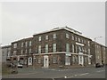
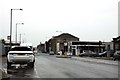
Pennine View Apartments, Dock Street, Fleetwood
Grade II Listed 1841-1845. Formerly The Crown Hotel.
Image: © Stephen Armstrong
Taken: 27 Sep 2018
0.05 miles
6
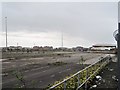
Fleetwood 1st railway station (site), Lancashire
Opened in 1840 by the Preston & Wyre Joint Railway (joint between the Lancashire & Yorkshire Railway and the London & North Western Railway), this station closed in 1851 when it was replaced by a larger station covering the foreground and right of the image. In turn, that 1851 station was replaced by a third station adjacent to the ferry terminal, several hundred metres behind the camera position.
View south west from Dock Street. In the 1840s, the Crown Hotel would have stood where the building on the right of the image now is, at the end of Church Street, with the railway passenger terminus immediately to the left of it. In later years, this whole area was covered by railway tracks and warehouses, then later still by a car-park for the ferries. Not surprisingly therefore, nothing remains of either the 1840 or 1851 stations. The whole area was derelict when this image was taken.
See also Image and Image 2nd and 3rd railway station sites. There was even a fourth station site as the railway was cut back to the former "Wyre Dock" station in 1966 and it was renamed "Fleetwood".
Image: © Nigel Thompson
Taken: 12 Apr 2017
0.05 miles
8
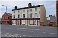
The Victoria (1), 42-46 Dock Street, Fleetwood
A closed pub, which claimed to be the oldest pub in Fleetwood, according to the faded signage on the building. There seems to be some suggestion that it may be turned into flats, but this may not have been decided. It would need planning permission to change the use.
Image
It should be said that a boundary between OS squares goes right across this pub, but as the majority of it seems to be in SD3347, according to the website "Where's the Path?", that is where I have put it. Also the small scale of the OS map for this square, makes it look as if the pub is on the east side of Dock Road, but it is actually on the west side.
Image: © P L Chadwick
Taken: 6 May 2011
0.08 miles
9
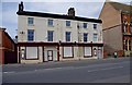
The Victoria (2), 42-46 Dock Street, Fleetwood
This pub closed fairly recently. Another one in this area, the Fleetwood Arms, has also closed. The latter is apparently being turned into a dentist's surgery.
Image
Image: © P L Chadwick
Taken: 6 May 2011
0.08 miles
10
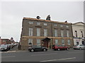
Chapman Court Flats, Dock Street, Fleetwood
Formerly a hotel for the Preston & Wyre Railway with the railway offices attached to the right. Grade II Listed 1836-1841. There is an OS Cut Benchmark Image on the bottom left corner.
Image: © Stephen Armstrong
Taken: 27 Sep 2018
0.08 miles