IMAGES TAKEN NEAR TO
Wardleys Lane, POULTON-LE-FYLDE, FY6 9DX
Introduction
This page details the photographs taken nearby to Wardleys Lane, FY6 9DX by members of the Geograph project.
The Geograph project started in 2005 with the aim of publishing, organising and preserving representative images for every square kilometre of Great Britain, Ireland and the Isle of Man.

There are currently over 7.5m images from over14,400 individuals and you can help contribute to the project by visiting https://www.geograph.org.uk
Image Map
Images are licensed for reuse under creativecommons.org/licenses/by-sa/2.0
Notes
- Clicking on the map will re-center to the selected point.
- The higher the marker number, the further away the image location is from the centre of the postcode.
Image Listing (12 Images Found)
Images are licensed for reuse under creativecommons.org/licenses/by-sa/2.0
Image
Details
Distance
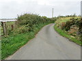
1
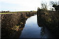
Drain near Staynall
Off Wardley's Lane, not apparent on OS 1:25000 map.
Image: © Bob Jenkins
Taken: 17 Jan 2009
0.09 miles
2
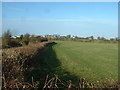
Farmland near Staynall
Staynall hamlet is on the horizon.
Image: © David Medcalf
Taken: 21 Jan 2006
0.11 miles
3
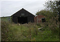
Ruined garage and workshops at Staynall
Image: © Tom Richardson
Taken: 10 Sep 2008
0.11 miles
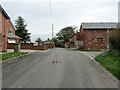
4
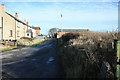
Staynall
A small compact collection of dwellings and buildings.
Image: © Bob Jenkins
Taken: 17 Jan 2009
0.14 miles
5
Staynall
Small village on the eastern side of the Wyre Estuary.
Image: © Chris Heaton
Taken: 5 Oct 2011
0.15 miles
6
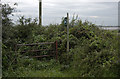
Overgrown footpath from Burrows Lane
Image: © Tom Richardson
Taken: 10 Sep 2008
0.15 miles
7
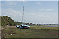
A boat on the salt marsh
I'm not sure if the boat is abandoned. It certainly needs a fair bit of work to make it seaworthy.
Image: © Ian Greig
Taken: 18 Sep 2018
0.16 miles
8
The muddy path down to the riverside
There's some shelter from the wind at this point.
Image: © Ian Greig
Taken: 18 Sep 2018
0.16 miles
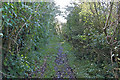
9
Burrow's Lane leaving Staynall
Adopted by the Wyre Way long distance footpath, this shows Burrow's Lane leaving north from Staynall
Image: © Chris Heaton
Taken: 5 Oct 2011
0.17 miles
