IMAGES TAKEN NEAR TO
Longhouse Lane, POULTON-LE-FYLDE, FY6 8DE
Introduction
This page details the photographs taken nearby to Longhouse Lane, FY6 8DE by members of the Geograph project.
The Geograph project started in 2005 with the aim of publishing, organising and preserving representative images for every square kilometre of Great Britain, Ireland and the Isle of Man.

There are currently over 7.5m images from over14,400 individuals and you can help contribute to the project by visiting https://www.geograph.org.uk
Image Map (Loading...)


Getting Data...Please wait
Leaflet Map data © OpenStreetMap
Images are licensed for reuse under creativecommons.org/licenses/by-sa/2.0
Notes
- Clicking on the map will re-center to the selected point.
- The higher the marker number, the further away the image location is from the centre of the postcode.
Image Listing (7 Images Found)
Images are licensed for reuse under creativecommons.org/licenses/by-sa/2.0
Image
Details
Distance

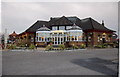
3

Harvester
The sign says 'Harvester' but to locals it's still the 'Highcross'.
Image: © Peter Bond
Taken: 4 Jul 2009
0.12 miles
5
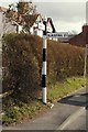
Direction Sign - Signpost at High Cross, Poulton-Le-Fylde
Nipple finial - 3 arms; by the B5266, in parish of Staining (Fylde District), Normoss Road junction with Staining Old Road.
To be surveyed
Milestone Society National ID: LA_SD3437
Image: © Milestone Society
Taken: Unknown
0.14 miles
6
English Martyrs, Poulton le Fylde
English Martyrs Poulton le Fylde, founded in 1962.
Image: © Steve Houldsworth
Taken: Unknown
0.15 miles
7
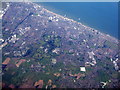
Blackpool and Poulton le Fylde
An aerial view from above The Fylde. Tower is between the North Pier [RH side] and the adjacent Central Pier.
Image: © M J Richardson
Taken: 26 Sep 2015
0.21 miles