IMAGES TAKEN NEAR TO
Derwent Close, POULTON-LE-FYLDE, FY6 0QF
Introduction
This page details the photographs taken nearby to Derwent Close, FY6 0QF by members of the Geograph project.
The Geograph project started in 2005 with the aim of publishing, organising and preserving representative images for every square kilometre of Great Britain, Ireland and the Isle of Man.

There are currently over 7.5m images from over14,400 individuals and you can help contribute to the project by visiting https://www.geograph.org.uk
Image Map (Loading...)


Getting Data...Please wait
Leaflet Map data © OpenStreetMap
Images are licensed for reuse under creativecommons.org/licenses/by-sa/2.0
Notes
- Clicking on the map will re-center to the selected point.
- The higher the marker number, the further away the image location is from the centre of the postcode.
Image Listing (21 Images Found)
Images are licensed for reuse under creativecommons.org/licenses/by-sa/2.0
Image
Details
Distance
3
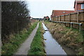
Polluted Ditch and Public Footpath
A smart new housing development to the west is screened from this rather unpleasant short path.
Image: © Bob Jenkins
Taken: 14 Jan 2009
0.11 miles
4
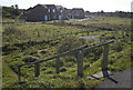
Access path to new housing estate,near Knott End
Image: © Tom Richardson
Taken: 5 Oct 2008
0.11 miles
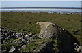
6
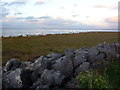
Salt marsh beyond the sea wall at Knott End
Image: © John H Darch
Taken: 23 Nov 2012
0.12 miles
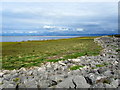
7
Salt marsh and sea wall north east of Knott End
Image: © John H Darch
Taken: 23 Nov 2012
0.16 miles
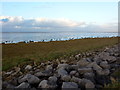
8
Coastal Defences at Knott End on Sea
Boulders placed on the seaward side of the embankment that carries the Lancashire Coastal path
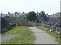
Image: © Chris Heaton
Taken: 31 Aug 2011
0.16 miles
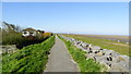
9
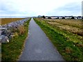
Lancashire Coastal Way Leaving Knott End
Walking along the Lancashire Coastal Way and about to leave Knott End behind before coming to the first of two caravan parks.
Image: © Rude Health
Taken: 10 Mar 2013
0.19 miles
10
Caravan Site on Pilling Lane Preesall
The gate gives access to the coastal path behind the site.
Image: © Tom Richardson
Taken: 5 Oct 2008
0.20 miles