IMAGES TAKEN NEAR TO
Cemetery Lane, POULTON-LE-FYLDE, FY6 0PH
Introduction
This page details the photographs taken nearby to Cemetery Lane, FY6 0PH by members of the Geograph project.
The Geograph project started in 2005 with the aim of publishing, organising and preserving representative images for every square kilometre of Great Britain, Ireland and the Isle of Man.

There are currently over 7.5m images from over14,400 individuals and you can help contribute to the project by visiting https://www.geograph.org.uk
Image Map
Images are licensed for reuse under creativecommons.org/licenses/by-sa/2.0
Notes
- Clicking on the map will re-center to the selected point.
- The higher the marker number, the further away the image location is from the centre of the postcode.
Image Listing (20 Images Found)
Images are licensed for reuse under creativecommons.org/licenses/by-sa/2.0
Image
Details
Distance
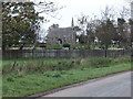
2
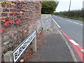
Burned House Lane
The A588 by the crossroads near Preesall Park, north of Stalmine. Despite quite a bit of research, thus far I've been unable to find out which unfortunate house gave rise to this road-name.
Image: © Barbara Carr
Taken: 30 Oct 2013
0.03 miles
3
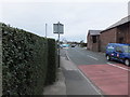
Park Lane from the crossroads north of Stalmine
This is a hazardous junction to negotiate in any direction when on foot, visibility being very limited from the few spots which are safe to stand upon, this being the best bit - but even from here, traffic waiting at the right of picture hides whatever's coming from the east, and the return trip is a bit of a 'Hokey-Cokey' experience due to the buildings obscuring the view along Park Lane. Mid-afternoon, drivers were very mindful and courteous, but I wouldn't like to tackle this junction at rush-hour.
Image: © Barbara Carr
Taken: 30 Oct 2013
0.04 miles
4
Besieged in Preesall
This poor woman seemed to be under attack on all sides as she tried to usher her canine charges across the road.
Image: © Chris
Taken: 31 Jul 2014
0.05 miles
5
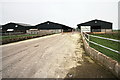
Three Black Sheds
On Park Farm, for cattle.
Image: © Bob Jenkins
Taken: 5 Mar 2009
0.05 miles

7
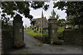
Preesall cemetery, Cemetery Lane, Preesall
Image: © Tom Richardson
Taken: 10 Sep 2008
0.08 miles

10
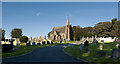
The chapel at Preesall Cemetery
Seen from Cemetery Lane, en route from Back Lane to the A588.
Image: © Barbara Carr
Taken: 30 Oct 2013
0.09 miles