IMAGES TAKEN NEAR TO
Gaulters Lane, POULTON-LE-FYLDE, FY6 0NX
Introduction
This page details the photographs taken nearby to Gaulters Lane, FY6 0NX by members of the Geograph project.
The Geograph project started in 2005 with the aim of publishing, organising and preserving representative images for every square kilometre of Great Britain, Ireland and the Isle of Man.

There are currently over 7.5m images from over14,400 individuals and you can help contribute to the project by visiting https://www.geograph.org.uk
Image Map
Images are licensed for reuse under creativecommons.org/licenses/by-sa/2.0
Notes
- Clicking on the map will re-center to the selected point.
- The higher the marker number, the further away the image location is from the centre of the postcode.
Image Listing (14 Images Found)
Images are licensed for reuse under creativecommons.org/licenses/by-sa/2.0
Image
Details
Distance
1
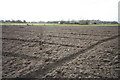
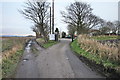
Ploughed Footpath
The public footpath runs diagonally across this ploughed field; waterlogged edges prevent a detour.
Image: © Bob Jenkins
Taken: 23 Feb 2009
0.07 miles
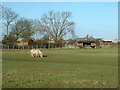
4
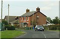
Cat and Dog Kennels
Also quarantine kennels, next to (appropriately) Little Tongues Farm, Preesall.
Image: © Bob Jenkins
Taken: 13 Feb 2009
0.16 miles
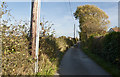
8
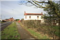
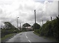
House on the B5270
The unusual feature of this house is its orientation to the road - it was in fact lined up to the old Garstang and Knott End Railway, and therefore was probably associated with it.
Image: © Bob Jenkins
Taken: 23 Feb 2009
0.18 miles