IMAGES TAKEN NEAR TO
Wayside, POULTON-LE-FYLDE, FY6 0DD
Introduction
This page details the photographs taken nearby to Wayside, FY6 0DD by members of the Geograph project.
The Geograph project started in 2005 with the aim of publishing, organising and preserving representative images for every square kilometre of Great Britain, Ireland and the Isle of Man.

There are currently over 7.5m images from over14,400 individuals and you can help contribute to the project by visiting https://www.geograph.org.uk
Image Map (Loading...)


Getting Data...Please wait
Leaflet Map data © OpenStreetMap
Images are licensed for reuse under creativecommons.org/licenses/by-sa/2.0
Notes
- Clicking on the map will re-center to the selected point.
- The higher the marker number, the further away the image location is from the centre of the postcode.
Image Listing (123 Images Found)
Images are licensed for reuse under creativecommons.org/licenses/by-sa/2.0
Image
Details
Distance
2
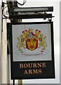
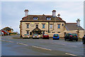
Sign of the Bourne Arms
Sign for the Bourne Arms Image
The coat of arms on the sign is that of the county of Lancashire http://www.ngw.nl/heraldrywiki/index.php?title=Lancashire bearing the motto IN CONCILIO CONSILIUM - In council is wisdom.
Image: © Gerald England
Taken: 27 Aug 2016
0.04 miles
3
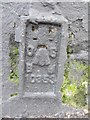
Ordnance Survey Flush Bracket (10353)
This OS Flush Bracket can be found on the Bourne Hotel. It marks a height 7.212m above mean sea level.
Image: © Adrian Dust
Taken: 4 Apr 2014
0.04 miles
4
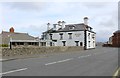
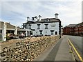
Bourne Arms at Knott End
The only pub in Knott End. Overlooks Morecambe Bay.
Image: © Richard Hoare
Taken: 8 Apr 2016
0.04 miles
6
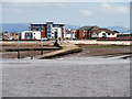
Lune Estuary and Knott End Ferry Slipway
Looking across the Lune estuary from the beach at Fleetwood towards the slipway at Knott End.
Image: © David Dixon
Taken: 17 Jul 2016
0.05 miles

8

Knott End-on-Sea, the view from Fleetwood
Looking across the estuary of the River Lune, from Fleetwood.
Image: © David Dixon
Taken: 17 Jul 2016
0.05 miles
9
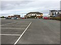
Knott End railway station (site), Lancashire
Opened in 1908 by the Knott End Railway, this was the terminus of the line from Garstang. It closed to passengers in 1930 and completely in 1950.
View north along the line towards the site of the buffer stops. The building at the end is partly original but much altered.
Image: © Nigel Thompson
Taken: 12 Apr 2017
0.06 miles
10
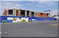
Uncompleted Waterfront development at Bourne May Road in May 2011, Knott End-on-Sea
Construction of this development of apartments came to a halt in 2008, because of falling demand in the housing market triggered by the financial crisis. The result was this eyesore, which is in a prominent position by the pier used by the ferry to Fleetwood. It seems that in late 2011 the developers submitted revised plans to the planning authority, with the hope that work could recommence in 2012 and be completed by the autumn of 2013.
Image: © P L Chadwick
Taken: 6 May 2011
0.06 miles