IMAGES TAKEN NEAR TO
Phillip Street, BLACKPOOL, FY4 4DE
Introduction
This page details the photographs taken nearby to Phillip Street, FY4 4DE by members of the Geograph project.
The Geograph project started in 2005 with the aim of publishing, organising and preserving representative images for every square kilometre of Great Britain, Ireland and the Isle of Man.

There are currently over 7.5m images from over14,400 individuals and you can help contribute to the project by visiting https://www.geograph.org.uk
Image Map
Images are licensed for reuse under creativecommons.org/licenses/by-sa/2.0
Notes
- Clicking on the map will re-center to the selected point.
- The higher the marker number, the further away the image location is from the centre of the postcode.
Image Listing (21 Images Found)
Images are licensed for reuse under creativecommons.org/licenses/by-sa/2.0
Image
Details
Distance
1
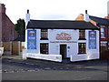
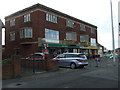
"The Cottage" Famous for Fish & Chips Since 1940
http://www.cottagefishandchips.co.uk/
Image: © Robert Wade
Taken: 4 Dec 2009
0.05 miles
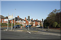
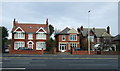
2
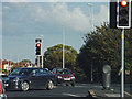
Blackpool : Preston New Road A583
Preston New Road at the traffic lights and junction with South Park Drive.
Image: © Lewis Clarke
Taken: 12 Oct 2014
0.09 miles
3
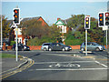
Blackpool : Preston New Road A583
At the traffic lights at the junction with Preston New Road with South Park Drive.
Image: © Lewis Clarke
Taken: 12 Oct 2014
0.09 miles
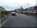
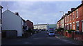
6
South Park Drive
The junction at South Park Drive. This road leads eventually to Blackpool Zoo.
Image: © Malcolm Neal
Taken: 18 Oct 2018
0.11 miles
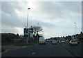
10
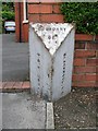
Old Boundary Marker on Preston New Road
Parish Boundary Marker by the A583, in parish of Blackpool (Fylde District), on the north side of the eastern carriageway of Preston New Road, outside No 53 and opposite the junction with Joyce Avenue.
surveyed
Milestone Society National ID: LA_BPPS02pb
Image: © Milestone Society
Taken: 8 Jun 2012
0.12 miles