IMAGES TAKEN NEAR TO
Mayfair Road, BLACKPOOL, FY1 6QZ
Introduction
This page details the photographs taken nearby to Mayfair Road, FY1 6QZ by members of the Geograph project.
The Geograph project started in 2005 with the aim of publishing, organising and preserving representative images for every square kilometre of Great Britain, Ireland and the Isle of Man.

There are currently over 7.5m images from over14,400 individuals and you can help contribute to the project by visiting https://www.geograph.org.uk
Image Map (Loading...)


Getting Data...Please wait
Leaflet Map data © OpenStreetMap
Images are licensed for reuse under creativecommons.org/licenses/by-sa/2.0
Notes
- Clicking on the map will re-center to the selected point.
- The higher the marker number, the further away the image location is from the centre of the postcode.
Image Listing (21 Images Found)
Images are licensed for reuse under creativecommons.org/licenses/by-sa/2.0
Image
Details
Distance
1
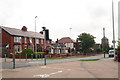
Park Road after the junction with Bloomfield Road
Image: © Chris
Taken: 31 Jul 2014
0.10 miles
2
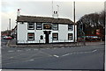
The Saddle
One of the oldest pubs in Blackpool famous for its real ale
Image: © Keith Wright
Taken: 24 Feb 2006
0.13 miles
3
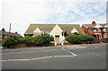
Closed Library
Marton Branch Library is now no more.
Image: © Bob Jenkins
Taken: 18 Jun 2009
0.14 miles
4
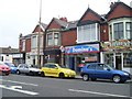
Domino's Pizza
On Waterloo Road, Blackpool.
Image: © Stephen Sweeney
Taken: 30 Jun 2009
0.15 miles
6

War Memorial Base and Inscription
A closer view of Image], showing the base and the inscription:
THIS CROSS
THE GIFT OF MR & MRS JP DIXON
OF THE MOUNT
IS ERECTED TO THE GLORY OF GOD
AND IN PROUD MEMORY OF
THESE MARTON MEN
WHO GAVE THEIR LIVES
IN THE GREAT WAR
1914 - 1919
Image: © David Dixon
Taken: 24 Dec 2014
0.18 miles
7

War Memorial & St Paul's Church, Marton
The war memorial is set in front of the grass outside Image It is on the corner of Honister Avenue and Whitegate Drive.
See Image] for a closer view of the inscription.
Image: © David Dixon
Taken: 24 Dec 2014
0.18 miles
8
Brun Grove
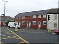
The street has a strange history; the dip in the middle was due to subsidence caused after the Spen Dyke (that drained the Black Pool) was culverted and the land dried. The row of terraced houses on the left were built on a concrete slab, and slowly sank about 3 metres, resulting in regular flooding with sewage when Blackpool's sewer system, the weather and tides conspired. The occupants were eventually rehoused, the floors raised with even more concrete and the premises became commercial.
Image: © Bob Jenkins
Taken: 18 Jun 2009
0.18 miles
9
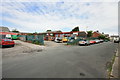
Industrial Estate, Brun Grove
Formerly a scrapyard and recycling venture, builder's yards, and housing for some of Blackpool's donkeys graced this little industrial estate surrounded by residential housing.
Image: © Bob Jenkins
Taken: 18 Jun 2009
0.18 miles
10
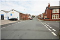
Blackpool : Preston New Road
From Whitegate Drive looking towards Preston New Road.
Image: © Lewis Clarke
Taken: 12 Oct 2014
0.18 miles