IMAGES TAKEN NEAR TO
Threlfall Road, BLACKPOOL, FY1 6NN
Introduction
This page details the photographs taken nearby to Threlfall Road, FY1 6NN by members of the Geograph project.
The Geograph project started in 2005 with the aim of publishing, organising and preserving representative images for every square kilometre of Great Britain, Ireland and the Isle of Man.

There are currently over 7.5m images from over14,400 individuals and you can help contribute to the project by visiting https://www.geograph.org.uk
Image Map (Loading...)


Getting Data...Please wait
Leaflet Map data © OpenStreetMap
Images are licensed for reuse under creativecommons.org/licenses/by-sa/2.0
Notes
- Clicking on the map will re-center to the selected point.
- The higher the marker number, the further away the image location is from the centre of the postcode.
Image Listing (14 Images Found)
Images are licensed for reuse under creativecommons.org/licenses/by-sa/2.0
Image
Details
Distance
1
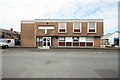
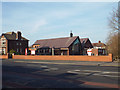
Brun Grove W.M.C.
The right hand corner of the club lies within the adjacent gridsquare; however, most of the building is in SD3134
Image: © Bob Jenkins
Taken: 18 Jun 2009
0.13 miles
3
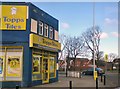
Topps Tiles
On the corner of Waterloo Road and Marton Drive.
Image: © Gerald England
Taken: 14 Apr 2012
0.18 miles
4
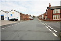
Brun Grove
The street has a strange history; the dip in the middle was due to subsidence caused after the Spen Dyke (that drained the Black Pool) was culverted and the land dried. The row of terraced houses on the left were built on a concrete slab, and slowly sank about 3 metres, resulting in regular flooding with sewage when Blackpool's sewer system, the weather and tides conspired. The occupants were eventually rehoused, the floors raised with even more concrete and the premises became commercial.
Image: © Bob Jenkins
Taken: 18 Jun 2009
0.19 miles
5
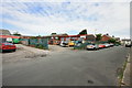
Industrial Estate, Brun Grove
Formerly a scrapyard and recycling venture, builder's yards, and housing for some of Blackpool's donkeys graced this little industrial estate surrounded by residential housing.
Image: © Bob Jenkins
Taken: 18 Jun 2009
0.19 miles
6
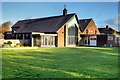
Holy Cross Church and Parish Centre, Blackpool
http://www.holycrossblackpool.co.uk/ Church Website
Image: © David Dixon
Taken: 24 Dec 2014
0.19 miles
7
Holy Cross Parish Church and centre, Central Drive, Blackpool
Image: © Robin Stott
Taken: 20 Apr 2015
0.19 miles
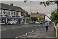
9
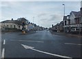
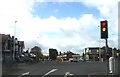
Waterloo Road, Blackpool
At the junction with St Anne's Road. To the north of this point (to the left of picture) St Anne's Road becomes Central Drive.
Image: © Barbara Carr
Taken: 21 Oct 2013
0.23 miles
10
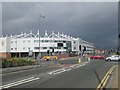
Bloomfield Road Stadium, home of Blackpool Football Club
Not only a football stadium but also a conference centre, sports centre and hotel with a casino on the north side of the stadium.
Image: © James Denham
Taken: 24 Jun 2014
0.23 miles