IMAGES TAKEN NEAR TO
Stan Mortensen Avenue, BLACKPOOL, FY1 5FA
Introduction
This page details the photographs taken nearby to Stan Mortensen Avenue, FY1 5FA by members of the Geograph project.
The Geograph project started in 2005 with the aim of publishing, organising and preserving representative images for every square kilometre of Great Britain, Ireland and the Isle of Man.

There are currently over 7.5m images from over14,400 individuals and you can help contribute to the project by visiting https://www.geograph.org.uk
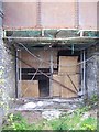
Image Map
Images are licensed for reuse under creativecommons.org/licenses/by-sa/2.0
Notes
- Clicking on the map will re-center to the selected point.
- The higher the marker number, the further away the image location is from the centre of the postcode.
Image Listing (265 Images Found)
Images are licensed for reuse under creativecommons.org/licenses/by-sa/2.0
Image
Details
Distance
1
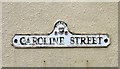
Caroline Street
Street name sign for Caroline Street Image in the Foxhall area of Blackpool.
Image: © Gerald England
Taken: 5 Mar 2014
0.04 miles
2
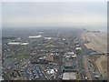
South Blackpool from the Tower
Bloomfield Road stadium, the Pleasure Beach, the Promenade and the beach front are just some of the notable landmarks in this image.
Image: © Stephen Sweeney
Taken: 30 Jun 2009
0.04 miles
3
Corner of Princess Street and Caroline Street
The corner of Princess Street and Caroline Street Image
Image: © Gerald England
Taken: 5 Mar 2014
0.04 miles
4
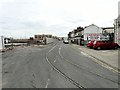
Old Tram Lines
Leading to the Rigby Road Tram Depot now used only by the Heritage Trams.
Image: © Gerald England
Taken: 5 Mar 2014
0.04 miles
5
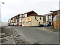
Demolition on Blundell Street
Note that there are still tram tracks in the road, but this loop is no longer used and the overhead wires have been removed.
Image: © Keith Edkins
Taken: 13 Mar 2015
0.05 miles
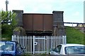
6
Disused Railway Subway, Central, Blackpool - 2
Image: © Terry Robinson
Taken: 2 May 2010
0.06 miles
7
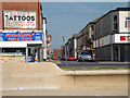
A view east down Bairstow Street from Blackpool Promenade
Bairstow Street leads to Caroline Street and what seems to be an electricity substation, anonymous as far as can be seen from Streetview. In the foreground is sea-facing profiled seating in smooth concrete.
Image: © Robin Stott
Taken: 20 Apr 2015
0.06 miles
8
Disused Railway Subway, Central, Blackpool - 1
This former subway gave access 'under' the railway lines of the former L.M.S. Railway heading into and from Blackpool Central Station. The station closed in 1964 but the site of the former lines ... and there were 14 at one stage bringing thousands of visitors to Blackpool ... is now a road and car parking area. The subway is shown on the 1932 OS Map but will date from the early 1900s. The grey bricks are atypical of the former railway architecture and is reflected in many of the former railway bridges which still in the area. Not sure when it was finally closed off. Image
Image: © Terry Robinson
Taken: 2 May 2010
0.07 miles
9
Seasiders Way over Rigby Road
The bridge over Rigby Road used to carry the railway line into Blackpool Central station. The station was closed in 1964. Now the bridge carries the road Seasiders Way which leads into the Central car park. On the right is a footpath Image which leads to Rigby Road Image In the background is the Bloomfield Road ground of Blackpool F.C.
Image: © Gerald England
Taken: 9 Mar 2014
0.07 miles
10
Footpath off Rigby Road
The footpath leads off Rigby Road Image to the Central Car Park Image built on the former Blackpool Central station and sidings.
Image: © Gerald England
Taken: 9 Mar 2014
0.07 miles