IMAGES TAKEN NEAR TO
Talbot Road, BLACKPOOL, FY1 1LR
Introduction
This page details the photographs taken nearby to Talbot Road, FY1 1LR by members of the Geograph project.
The Geograph project started in 2005 with the aim of publishing, organising and preserving representative images for every square kilometre of Great Britain, Ireland and the Isle of Man.

There are currently over 7.5m images from over14,400 individuals and you can help contribute to the project by visiting https://www.geograph.org.uk
Image Map
Images are licensed for reuse under creativecommons.org/licenses/by-sa/2.0
Notes
- Clicking on the map will re-center to the selected point.
- The higher the marker number, the further away the image location is from the centre of the postcode.
Image Listing (579 Images Found)
Images are licensed for reuse under creativecommons.org/licenses/by-sa/2.0
Image
Details
Distance
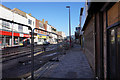
1

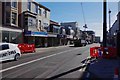
New tram tracks in Talbot Road, Blackpool
Part of the extension along Talbot Road to Blackpool North Station. It is not due to open for some months.
Image: © P L Chadwick
Taken: 12 May 2019
0.01 miles
2
New tram tracks in Talbot Road, Blackpool
The recently laid tram tracks in Talbot Road which are part of the extension to Blackpool North Station. This view is looking in the direction ofb the Promenade. The tracks are passing a shop run by the Blackpool & North Lancashire branch of the RSPCA on the left.
Image: © P L Chadwick
Taken: 12 May 2019
0.01 miles
3
Talbot Road
The final stretch of the A586 from Poulton-le-Fylde.
Image: © Gerald England
Taken: 8 Apr 2013
0.02 miles
4
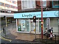
Lloyds Pharmacy
On Talbot Road at the junction with Topping Street.
Image: © Gerald England
Taken: 10 Apr 2012
0.02 miles
5
Talbot Road
The A586 leads down into Talbot Square to end by the North Pier. Lloyds Pharmacy is on the corner with Topping Street. The top of the tower can just be seen peeping over the rooftops.
Image: © Gerald England
Taken: 21 Jul 2017
0.02 miles
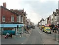
7

Talbot Road
A busy scene on Talbot Road with a stream of traffic climbing up into the town. The bus is turning right into Topping Street. The left turn lane is for traffic joining Dickson Road. Talbot Road is currently a one way street in the opposite direction to the oncoming traffic in the photo.
Image: © Martin Addison
Taken: Unknown
0.03 miles
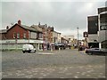
8

Blackpool : Talbot Road Roundabout
A roundabout on Talbot Road with Dickinson Road and Topping Street in view.
Image: © Lewis Clarke
Taken: 12 Oct 2014
0.04 miles
9

Tram tracks at Wilko (1), Talbot Road, Blackpool
The recently laid rails for the tramway extension along Talbot Road to Blackpool North Station currently end outside the Wilko store. This store is due to be demolished after which the tracks will be continued onto the site of the store, where the terminus stop will be built. This will have access to the railway station.
Image
Image: © P L Chadwick
Taken: 12 May 2019
0.04 miles
10

Tram tracks at Wilko (2), Talbot Road, Blackpool
The Wilko store with a multi-storey car park above is on the corner of Talbot Road and Dickson Road. Outside in Talbot Road the recently laid tracks for the extension to Blackpool North Station currently terminate. The store's site is where the new tramway terminus will be built. This will be the first extension to the tramway since the Promenade line was extended to Starr Gate in 1926. After that all the inland routes in Blackpool were gradually closed in the 1930's and 1960's. This extension will mean that once again there will be a street-running section of line running in the town centre.
Image
Image: © P L Chadwick
Taken: 12 May 2019
0.04 miles