
IMAGES TAKEN NEAR TO
Ladysneuk Road, STIRLING, FK9 5NG
Introduction
This page details the photographs taken nearby to Ladysneuk Road, FK9 5NG by members of the Geograph project.
The Geograph project started in 2005 with the aim of publishing, organising and preserving representative images for every square kilometre of Great Britain, Ireland and the Isle of Man.

There are currently over 7.5m images from over14,400 individuals and you can help contribute to the project by visiting https://www.geograph.org.uk
Image Map
Images are licensed for reuse under creativecommons.org/licenses/by-sa/2.0
Notes
- Clicking on the map will re-center to the selected point.
- The higher the marker number, the further away the image location is from the centre of the postcode.
Image Listing (70 Images Found)
Images are licensed for reuse under creativecommons.org/licenses/by-sa/2.0
Image
Details
Distance
1
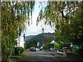
Cambuskenneth, Ladysneuk Road
The ever present national monument to sir William Wallace dominating the village.
Image: © Robert Murray
Taken: 24 Sep 2011
0.01 miles
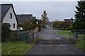
3
![Cambuskenneth, South Street [4]](https://s0.geograph.org.uk/geophotos/02/61/78/2617804_8ea8248e_120x120.jpg)
Cambuskenneth, South Street [4]
View to the castle of Stirling.
Image: © Robert Murray
Taken: 24 Sep 2011
0.02 miles
4
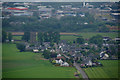
Cambuskenneth, Stirling
The abbey owned the land at Abbey Craig, the location of the Wallace Monument, form where this photo was taken.
Image: © Mike Pennington
Taken: 10 Jun 2013
0.04 miles
5
![Cambuskenneth, South Street [3]](https://s0.geograph.org.uk/geophotos/02/61/72/2617224_08505bdf_120x120.jpg)
Cambuskenneth, South Street [3]
Rather splendid double garage made of timber.
Image: © Robert Murray
Taken: 24 Sep 2011
0.05 miles
6

Cambuskenneth Abbey information
Image: © M J Richardson
Taken: 23 Feb 2016
0.05 miles
7
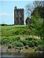
Bell tower, Cambuskenneth Abbey
Zoomed view, seen from a riverside path beside the River Forth. The bell tower, which probably dates to the late 13th century is the most intact part of the medieval abbey, which is a Scheduled Monument http://portal.historicenvironment.scot/designation/SM90055.
Image: © Richard Sutcliffe
Taken: 18 May 2022
0.05 miles
8
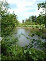
Bell tower, Cambuskenneth Abbey
Seen from a riverside path beside the River Forth. The bell tower, which probably dates to the late 13th century is the most intact part of the medieval abbey, which is a Scheduled Monument http://portal.historicenvironment.scot/designation/SM90055.
Image: © Richard Sutcliffe
Taken: 18 May 2022
0.05 miles
9
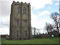
Tower at Cambuskenneth Abbey
The free-standing bell tower is all that survives to any great extent of the Augustinian Abbey founded here in 1147 Image
Image: © M J Richardson
Taken: 23 Feb 2016
0.05 miles
10
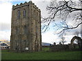
Cambuskenneth Abbey bell tower
The bell tower is all that remains standing of the abbey Image Closed in winter. Beyond are the Ochil Hills.
Image: © M J Richardson
Taken: 23 Feb 2016
0.05 miles