IMAGES TAKEN NEAR TO
Keir Street, STIRLING, FK9 4NW
Introduction
This page details the photographs taken nearby to Keir Street, FK9 4NW by members of the Geograph project.
The Geograph project started in 2005 with the aim of publishing, organising and preserving representative images for every square kilometre of Great Britain, Ireland and the Isle of Man.

There are currently over 7.5m images from over14,400 individuals and you can help contribute to the project by visiting https://www.geograph.org.uk
Image Map
Images are licensed for reuse under creativecommons.org/licenses/by-sa/2.0
Notes
- Clicking on the map will re-center to the selected point.
- The higher the marker number, the further away the image location is from the centre of the postcode.
Image Listing (110 Images Found)
Images are licensed for reuse under creativecommons.org/licenses/by-sa/2.0
Image
Details
Distance
1

Church hall, Bridge of Allan Parish Church
Built in 2008, the new building has a church Office, vestry, large hall with mezzanine, meeting room, kitchen and toilets.
Image: © Richard Sutcliffe
Taken: 2 Jun 2022
0.03 miles
2
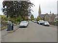
Keir Street in Bridge of Allan
Looking south-eastward.
Image: © Peter Wood
Taken: 4 Oct 2017
0.03 miles
3
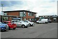
Bridge of Allan Healthcare Centre and library
Off Fountain Road.
Image: © Richard Sutcliffe
Taken: 2 Jun 2022
0.05 miles
4
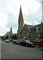
Two churches
The tall spire of the Category B listed http://portal.historicenvironment.scot/designation/LB22656 Bridge of Allan Parish Church (Church of Scotland), overlooks the smaller St Saviour's Scottish Episcopal Church (also Category B listed http://portal.historicenvironment.scot/designation/LB22657).
Image: © Richard Sutcliffe
Taken: 2 Jun 2022
0.06 miles
5
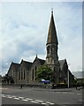
Bridge of Allan Parish Church
At the corner of Fountain Road and Keir Street. Dating from 1860, it was formerly Holy Trinity Parish Church. It is Category B listed http://portal.historicenvironment.scot/designation/LB22656.
Image: © Richard Sutcliffe
Taken: 2 Jun 2022
0.06 miles
6

The co-operative Food
Off Fountain Road.
Image: © Richard Sutcliffe
Taken: 2 Jun 2022
0.07 miles
7
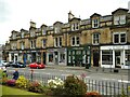
36-50 Henderson Street
All Category B listed http://portal.historicenvironment.scot/designation/LB22642 and dating from 1880, with shops at ground level and flats above.
Image: © Richard Sutcliffe
Taken: 2 Jun 2022
0.07 miles
8
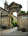
Archway to The Avenue
A mid-Victorian Category B listed http://portal.historicenvironment.scot/designation/LB22643 archway off Henderson Street.
Image: © Richard Sutcliffe
Taken: 2 Jun 2022
0.08 miles
9
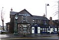
Westerton Arms and Clock, Bridge of Allan
Image: © Alpin Stewart
Taken: 1 Jan 2014
0.08 miles