IMAGES TAKEN NEAR TO
Inverallan Court, STIRLING, FK9 4JT
Introduction
This page details the photographs taken nearby to Inverallan Court, FK9 4JT by members of the Geograph project.
The Geograph project started in 2005 with the aim of publishing, organising and preserving representative images for every square kilometre of Great Britain, Ireland and the Isle of Man.

There are currently over 7.5m images from over14,400 individuals and you can help contribute to the project by visiting https://www.geograph.org.uk
Image Map
Images are licensed for reuse under creativecommons.org/licenses/by-sa/2.0
Notes
- Clicking on the map will re-center to the selected point.
- The higher the marker number, the further away the image location is from the centre of the postcode.
Image Listing (81 Images Found)
Images are licensed for reuse under creativecommons.org/licenses/by-sa/2.0
Image
Details
Distance
1
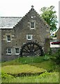
The Old Mill, Inverallan
Dating from 1710 the old grain mill was fully restored to working order in 1969, but the machinery was removed in 1979. It is Category B listed http://portal.historicenvironment.scot/designation/LB22698.
Image: © Richard Sutcliffe
Taken: 2 Jun 2022
0.03 miles
3
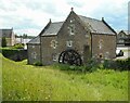
The Old Mill, Inverallan
Dating from 1710 the old grain mill was fully restored to working order in 1969, but the machinery was removed in 1979. It is Category B listed http://portal.historicenvironment.scot/designation/LB22698.
Image: © Richard Sutcliffe
Taken: 2 Jun 2022
0.03 miles
4
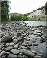
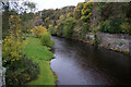
The Allan Water
Looking upstream from the edge of the river towards Mill of Airthrey Court on the right.
Image: © Richard Sutcliffe
Taken: 2 Jun 2022
0.03 miles
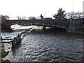
5
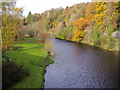
Bridge of Allan
The bridge over the Allan water in Bridge of Allan. The first bridge was built in 1520, and this is a 20th century version carrying the A9 between Stirling and Dunblane.
Image: © Richard Webb
Taken: 9 Jul 2005
0.03 miles
6
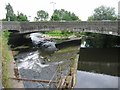
Allan Water
One of the tributaries of the Forth, the Allan is 22 miles long and rises in the Ochil Hills.
Image: © Euan Nelson
Taken: 7 Nov 2010
0.06 miles
7
Bridge of Allan, Allan Water
Unusual long weir that goes under the A9 bridge over the Allan to channel water into a mill lade.
Image: © Robert Murray
Taken: 19 Jul 2011
0.06 miles
9
![Bridge of Allan, Allan Water [2]](https://s0.geograph.org.uk/geophotos/02/51/35/2513584_e2dbec83_120x120.jpg)
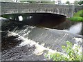
Bridge of Allan, Allan Water [2]
Upstream view from the bridge showing one of the two sluice gates on this weir.
Image: © Robert Murray
Taken: 19 Jul 2011
0.06 miles