IMAGES TAKEN NEAR TO
Fountain Road, STIRLING, FK9 4AT
Introduction
This page details the photographs taken nearby to Fountain Road, FK9 4AT by members of the Geograph project.
The Geograph project started in 2005 with the aim of publishing, organising and preserving representative images for every square kilometre of Great Britain, Ireland and the Isle of Man.

There are currently over 7.5m images from over14,400 individuals and you can help contribute to the project by visiting https://www.geograph.org.uk
Image Map
Images are licensed for reuse under creativecommons.org/licenses/by-sa/2.0
Notes
- Clicking on the map will re-center to the selected point.
- The higher the marker number, the further away the image location is from the centre of the postcode.
Image Listing (95 Images Found)
Images are licensed for reuse under creativecommons.org/licenses/by-sa/2.0
Image
Details
Distance
1

Bridge of Allan Healthcare Centre and library
Off Fountain Road.
Image: © Richard Sutcliffe
Taken: 2 Jun 2022
0.03 miles
2
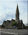
Bridge of Allan Parish Church
At the corner of Fountain Road and Keir Street. Dating from 1860, it was formerly Holy Trinity Parish Church. It is Category B listed http://portal.historicenvironment.scot/designation/LB22656.
Image: © Richard Sutcliffe
Taken: 2 Jun 2022
0.03 miles
3
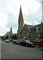
Two churches
The tall spire of the Category B listed http://portal.historicenvironment.scot/designation/LB22656 Bridge of Allan Parish Church (Church of Scotland), overlooks the smaller St Saviour's Scottish Episcopal Church (also Category B listed http://portal.historicenvironment.scot/designation/LB22657).
Image: © Richard Sutcliffe
Taken: 2 Jun 2022
0.04 miles
4
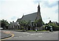
St Saviour's Episcopal Church
On the corner of Keir Street and Fountain Road. Dating from 1857, it is Category B listed http://portal.historicenvironment.scot/designation/LB22657.
Image: © Richard Sutcliffe
Taken: 2 Jun 2022
0.04 miles
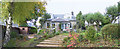
5

Church hall, Bridge of Allan Parish Church
Built in 2008, the new building has a church Office, vestry, large hall with mezzanine, meeting room, kitchen and toilets.
Image: © Richard Sutcliffe
Taken: 2 Jun 2022
0.05 miles
6
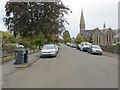
Keir Street in Bridge of Allan
Looking south-eastward.
Image: © Peter Wood
Taken: 4 Oct 2017
0.05 miles
7
Fountain of Nineveh, Bridge of Allan
Seen from Westerton Drive. The fountain is Listed Category B as 'mid 19th century', with no explanation of why it was erected or the origin of the name.
Image: © Alan Murray-Rust
Taken: 25 May 2022
0.06 miles
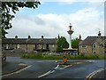
9

Fountain, Fountain Road
The fountain, which sits in the middle of a roundabout, dates from the mid-19th century and is Category B listed http://portal.historicenvironment.scot/designation/LB22624.
Image: © Richard Sutcliffe
Taken: 2 Jun 2022
0.06 miles
10
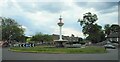
Roundabout, Fountain Road
The fountain dates from the mid-19th century and is Category B listed http://portal.historicenvironment.scot/designation/LB22624.
Image: © Richard Sutcliffe
Taken: 2 Jun 2022
0.06 miles