IMAGES TAKEN NEAR TO
Cameron Crescent, STIRLING, FK8 3EH
Introduction
This page details the photographs taken nearby to Cameron Crescent, FK8 3EH by members of the Geograph project.
The Geograph project started in 2005 with the aim of publishing, organising and preserving representative images for every square kilometre of Great Britain, Ireland and the Isle of Man.

There are currently over 7.5m images from over14,400 individuals and you can help contribute to the project by visiting https://www.geograph.org.uk
Image Map
Images are licensed for reuse under creativecommons.org/licenses/by-sa/2.0
Notes
- Clicking on the map will re-center to the selected point.
- The higher the marker number, the further away the image location is from the centre of the postcode.
Image Listing (53 Images Found)
Images are licensed for reuse under creativecommons.org/licenses/by-sa/2.0
Image
Details
Distance
1
Hillside House
Category C listed house http://portal.historicenvironment.scot/designation/LB8152 on Main Street.
Image: © Richard Sutcliffe
Taken: 22 Mar 2022
0.08 miles
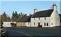
2
Ben View
Mid-19th century house at the corner of Main Street and Burnside. It is category C listed http://portal.historicenvironment.scot/designation/LB8153.
Image: © Richard Sutcliffe
Taken: 22 Mar 2022
0.08 miles
3
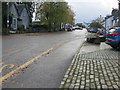
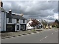
Main Street (B822) in Kippen
Looking south-westward.
Image: © Peter Wood
Taken: 2 Oct 2017
0.09 miles
4
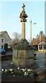
Kippen War Memorial
By A N Paterson, circa 1920. It is Category C listed http://portal.historicenvironment.scot/designation/LB8154.
To the Glory of GOD
and
in Memory of the
Men of KIPPEN Parish
who gave their lives
in the
GREAT WAR
1914-1919
Image: © Richard Sutcliffe
Taken: 22 Mar 2022
0.09 miles
5
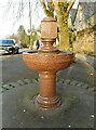
Drinking Fountain
Red granite drinking fountain set into the pavement on Main Street, Kippen. The inscription around the rim reads:
ERECTED BY THE COMMUNITY TO COMMEMORATE THE NEW WATER SUPPLY GRANTED BY THE LATE STEPHEN MITCHELL ESQ. OF BOQUHAN
AND AS A TOKEN OF GRATITUTE TO MRS STURROCK OF GLENTIRRAN, THROUGH WHOSE GENEROSITY IT WAS INTRODUCED
1921
Image: © Richard Sutcliffe
Taken: 22 Mar 2022
0.09 miles
6
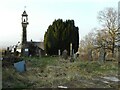
Kippen Old Kirk and kirkyard
The church was either built or rebuilt in 1691. All that now remains is the west gable, and the bell, which appears to pre-date the church (dated 1618). The structure is dangerous and so the kirkyard is closed until restoration work can be undertaken. This photograph was taken over the wall. The ruins are Category B listed http://portal.historicenvironment.scot/designation/LB8164.
Image: © Richard Sutcliffe
Taken: 22 Mar 2022
0.10 miles
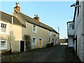
8
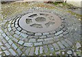
Wheel pattern
Set into cobbles outside the former Smiddy on Rennie's Loan.
Image: © Richard Sutcliffe
Taken: 22 Mar 2022
0.11 miles
9
The Old Smiddy
Now a National Trust for Scotland property, this late 18th century smiddy was gifted to the Trust in 1982 by Mr Andrew Rennie (b. 1890), 6th generation blacksmith in this village smiddy. It is category C listed http://portal.historicenvironment.scot/designation/LB8173.
Image: © Richard Sutcliffe
Taken: 22 Mar 2022
0.11 miles
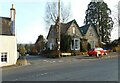
10
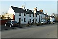
The Cross Keys
Parts of the building date from the late 18th century. It is Category C listed http://portal.historicenvironment.scot/designation/LB8179,
Image: © Richard Sutcliffe
Taken: 22 Mar 2022
0.11 miles