
IMAGES TAKEN NEAR TO
Friars Street, STIRLING, FK8 1HA
Introduction
This page details the photographs taken nearby to Friars Street, FK8 1HA by members of the Geograph project.
The Geograph project started in 2005 with the aim of publishing, organising and preserving representative images for every square kilometre of Great Britain, Ireland and the Isle of Man.

There are currently over 7.5m images from over14,400 individuals and you can help contribute to the project by visiting https://www.geograph.org.uk
Image Map
Images are licensed for reuse under creativecommons.org/licenses/by-sa/2.0
Notes
- Clicking on the map will re-center to the selected point.
- The higher the marker number, the further away the image location is from the centre of the postcode.
Image Listing (568 Images Found)
Images are licensed for reuse under creativecommons.org/licenses/by-sa/2.0
Image
Details
Distance
1

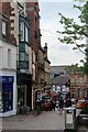
Friar Street
Between Murray Place and Baker Street.
Image: © Thomas Nugent
Taken: 20 Jun 2015
0.00 miles
3
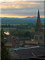
Stirling Baptist Church
The Ordnance Survey don't give the church a spire. It is near the railway station. The River Forth can be seen just meandering into the grid-square. In the distance is Knock Hill near Dunfermline.
Image: © Andrew Smith
Taken: 25 Jun 2006
0.01 miles
4
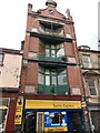
29-31 Friars Street, Stirling
John Allan, 1904. 4-storey single-bay building, recessed splayed fenestration with iron balconies, alternate at 1st floor. Red brick with ashlar dressings, idiosyncratic motifs.
Grade C listed. Listing number LB41293.
Image: © Andrew Abbott
Taken: 18 Aug 2020
0.02 miles
5
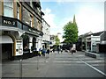
Friars Street
A pedestrianised street leading from Baker Street down to Murray Place. The building on the left is No.2 Baker Street on the corner of Baker Street and Friars Street. It dates from about 1905 and is Category C listed http://portal.historicenvironment.scot/designation/LB45363.
Image: © Richard Sutcliffe
Taken: 18 May 2022
0.02 miles
6
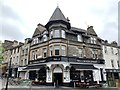
No.2 Baker Street
Formerly the Hog's Head public house.
Circa 1905. 3-storey obtusely angled public house on corner site with residential accommodation above. Keystoned round-arched arcade at ground, deep base course, chamfered corner bay, deep fascia. Squared and snecked sandstone to 1st floor with ashlar dressings; harled 2nd floor. String course above 1st floor and cill course to 2nd floor.
Grade C listed. Listing number LB45363.
Image: © Andrew Abbott
Taken: 18 Aug 2020
0.03 miles
7
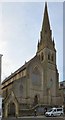
Stirling Baptist Church
According to the Church Buildings Renewal Trust https://web.archive.org/web/20190810060230/https://cbrt.org.uk/case_studies/stirling-baptist-church/
"Following many years of being vacant and neglected with proposals for commercial use coming and going, Stirling South Church (J W H and J M Hay, Liverpool 1851-3) was acquired by Stirling Baptist Church (SBC). SBC was located close by on the south side of Murray Place and an opportunity arose for that building to be acquired by developers of what is now the Thistles Centre. A combination of sale proceeds and grants from the Scottish Development Agency and Historic Scotland facilitated the internal transformation of the former South Church. This now includes a new floor inserted at gallery level, new meeting and other facilities at what would originally have been the main entrance floor level, a lift from street level to all upper levels, a new build sports hall to the rear and a large space with catering kitchen for church and community use at street level."
Trove.scot: https://www.trove.scot/place/221288
Church website: http://www.stirlingbaptist.org/
Image: © Gerald England
Taken: 22 Mar 2017
0.03 miles
8

Barnton Street
Looking towards Stirling Baptist Church.
Image: © Richard Sutcliffe
Taken: 18 May 2022
0.03 miles

10

Murray Place, Stirling
More or less the centre of Stirling's shopping area. Like most places there are a few vacant properties
Image: © Richard Webb
Taken: 11 Jul 2026
0.03 miles