IMAGES TAKEN NEAR TO
Coney Park, STIRLING, FK7 9LU
Introduction
This page details the photographs taken nearby to Coney Park, FK7 9LU by members of the Geograph project.
The Geograph project started in 2005 with the aim of publishing, organising and preserving representative images for every square kilometre of Great Britain, Ireland and the Isle of Man.

There are currently over 7.5m images from over14,400 individuals and you can help contribute to the project by visiting https://www.geograph.org.uk
Image Map
Images are licensed for reuse under creativecommons.org/licenses/by-sa/2.0
Notes
- Clicking on the map will re-center to the selected point.
- The higher the marker number, the further away the image location is from the centre of the postcode.
Image Listing (20 Images Found)
Images are licensed for reuse under creativecommons.org/licenses/by-sa/2.0
Image
Details
Distance
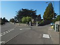
1
Stirling, Birkhill road
The road to Cambusbarron actually.
Image: © Robert Murray
Taken: 13 Mar 2011
0.07 miles
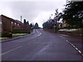
2
Birkhill Road
Birkhill Road is on the western side of Stirling. It joins Park Place to St. Ninian's Road.
Image: © Paul McIlroy
Taken: 12 Aug 2007
0.08 miles
3
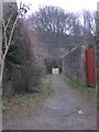
Path to King's Park
Path from Douglas Terrace leading to the King's Park golf course.
Image: © Callum Black
Taken: 24 Mar 2006
0.11 miles
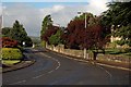
4
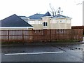
Junction of Birkhill Road and Douglas Terrace
This junction is depicted on the 1:25000 and 1:50000 maps. Douglas Terrace is the road branching off to the right. The building in the angle is Cliffside (1866, B-listed).
Image: © Lairich Rig
Taken: 21 Sep 2019
0.11 miles
6

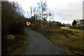
Path behind Douglas Terrace
The houses to the left are on Douglas Terrace. On the right is a steep slope leading up to King's Park: Image
Image: © Lairich Rig
Taken: 21 Sep 2019
0.16 miles
7
Path construction, King's Park
A hard path is being built up the scarp slope from Douglas Terrace. Paths in the park are rather muddy.
Image: © Richard Webb
Taken: 1 Feb 2017
0.16 miles
8
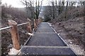
New path, King's Park
Construction of a tarred path in an otherwise very muddy park. The path ascends a gap in the crags on the scarp slope of a small hill.
Image: © Richard Webb
Taken: 1 Feb 2017
0.18 miles
10
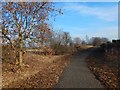
Path in King's Park
A path (Image) leading along the foot of the steep rocky escarpment reaches King's Park at about this point. For a view from further ahead, see Image
For the creation of these paths, see Image / Image
Image: © Lairich Rig
Taken: 24 Feb 2018
0.20 miles