IMAGES TAKEN NEAR TO
Main Street, STIRLING, FK7 8LZ
Introduction
This page details the photographs taken nearby to Main Street, FK7 8LZ by members of the Geograph project.
The Geograph project started in 2005 with the aim of publishing, organising and preserving representative images for every square kilometre of Great Britain, Ireland and the Isle of Man.

There are currently over 7.5m images from over14,400 individuals and you can help contribute to the project by visiting https://www.geograph.org.uk
Image Map
Images are licensed for reuse under creativecommons.org/licenses/by-sa/2.0
Notes
- Clicking on the map will re-center to the selected point.
- The higher the marker number, the further away the image location is from the centre of the postcode.
Image Listing (51 Images Found)
Images are licensed for reuse under creativecommons.org/licenses/by-sa/2.0
Image
Details
Distance
1
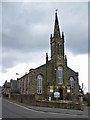
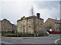
The Allan Church of Scotland, Bannockburn Cross
The Parish Church of Bannockburn opened October 1839. At the time, the parish had a population of 3176 people, and local industries included carpet, shawl and tartan manufacture and coal mining.
Church website: http://www.allanchurch.org/
Image: © Richard Dorrell
Taken: 3 Apr 2010
0.01 miles
2

War memorial, Bannockburn
The memorial stands in a small neat garden off Quakerfield. In this view, the shops on the left are at the eastern end of Main Street. Allan Church is on the right.
Image: © Richard Dorrell
Taken: 3 Apr 2010
0.02 miles
3
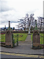
Memorial garden, Bannockburn
The gates to this small neat garden open from the junction between Quakerfield and Main Street in the centre of Bannockburn. The double-sided war memorial commemorates men from the neighbourhood who fell in the two world wars.
Image: © Richard Dorrell
Taken: 3 Apr 2010
0.03 miles
5
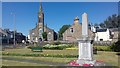
Bannockburn war memorial
The memorial stands in a small neat garden off Quakerfield, Allan Church is on the left.
Image: © Colin Kinnear
Taken: 1 Jul 2018
0.03 miles
6
Council Offices, Bannockburn
Built 1850 as a school house for James Wilson of Bannockburn Mill. In 1886 the school ceased to be private, and closed in 1899. School buildings to the rear were demolished in 1986 when the building was acquired by Stirling District Council. The building stands in Main Street at its junction with West Murrayfield in the centre of Bannockburn. It is currently the offices of the Community Services, Community Learning and Development Youth Team.
Image: © Richard Dorrell
Taken: 3 Apr 2010
0.04 miles
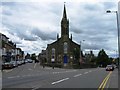
7
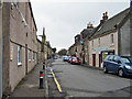
Main Street, Bannockburn
This road and the old town bridge to which it leads (behind the photographer) were by-passed by the building of New Road and a new bridge over the Bannock Burn in 1819 - which must be one of the earliest town centre by-passes ever built.
Image: © Richard Dorrell
Taken: 3 Apr 2010
0.06 miles
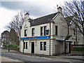
8
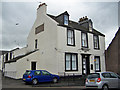
The Bannockburn Arms, Main Street
The building stands in the centre of this small town on the corner of West Murrayfield. There are function rooms to the rear. The business is currently for sale.
Image: © Richard Dorrell
Taken: 3 Apr 2010
0.06 miles
9
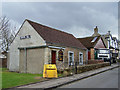
Gospel Hall, Bannockburn
One of many places of worship close to the centre of the small town of Bannockburn. This Gospel Hall is located in East Murrayfield, close to its junction with Quakerfield.
Image: © Richard Dorrell
Taken: 3 Apr 2010
0.06 miles
10
The Empire Bar, Quakerfield
One of several bars close to the centre of this small town.
Image: © Richard Dorrell
Taken: 3 Apr 2010
0.06 miles