IMAGES TAKEN NEAR TO
Duncarron Place, DENNY, FK6 6HL
Introduction
This page details the photographs taken nearby to Duncarron Place, FK6 6HL by members of the Geograph project.
The Geograph project started in 2005 with the aim of publishing, organising and preserving representative images for every square kilometre of Great Britain, Ireland and the Isle of Man.

There are currently over 7.5m images from over14,400 individuals and you can help contribute to the project by visiting https://www.geograph.org.uk
Image Map
Images are licensed for reuse under creativecommons.org/licenses/by-sa/2.0
Notes
- Clicking on the map will re-center to the selected point.
- The higher the marker number, the further away the image location is from the centre of the postcode.
Image Listing (35 Images Found)
Images are licensed for reuse under creativecommons.org/licenses/by-sa/2.0
Image
Details
Distance
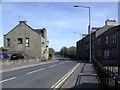
1
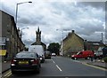
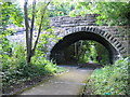
Footpath to Broad Street
Behind the photographer's position, this footpath runs parallel to Winchester Avenue, but is set above it at the top of a grassy bank. It then passes under the old railway bridge shown in this photo. (The history of the bridge is described at Image; see also Image)
After passing below the bridge, the footpath leads for another 100 metres to arrive at Broad Street.
Image: © Lairich Rig
Taken: 9 Nov 2009
0.05 miles
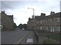
2

Mural beneath former railway bridge
For a description of the bridge itself, see Image; the stonework under the bridge is now covered on both sides by murals. Near the right-hand edge of the one shown here is the following description:
"This mural was created in partnership with the Community Green Initiative and the Community Safety Fund. It was painted by local artist Scott Gilbert and youth from Denny Community Flat".
Image: © Lairich Rig
Taken: 9 Nov 2009
0.05 miles
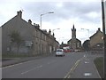
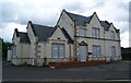
3
Denny, Broad Street
The road to Falkirk.
Image: © Robert Murray
Taken: 17 Apr 2011
0.05 miles
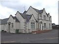
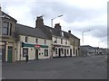
6
Broad St, Denny
On the left can be seen part of a police vehicle parked at the Police Station
Image: © John Lord
Taken: 24 Sep 2008
0.06 miles
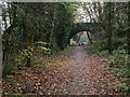
7
Railway bridge at Denny
Denny was the terminus of passenger trains from Larbert until 1930 but beyond the station two goods-only branches extended to serve paper mills, gravel and sand pits, brick works and collieries. Both extensions have been converted into footpaths since complete closure in the "Beeching era". This is Herbertshire Street bridge No.2 on the branch that ran northwards past Dunipace to Ingliston goods depot. The bridge has been closed to vehicles and now carries only a footpath over "The Old Railway Path".
Image: © A-M-Jervis
Taken: 26 Jul 2007
0.06 miles