IMAGES TAKEN NEAR TO
Roselynn Drive, FK6 6FN
Introduction
This page details the photographs taken nearby to Roselynn Drive, FK6 6FN by members of the Geograph project.
The Geograph project started in 2005 with the aim of publishing, organising and preserving representative images for every square kilometre of Great Britain, Ireland and the Isle of Man.

There are currently over 7.5m images from over14,400 individuals and you can help contribute to the project by visiting https://www.geograph.org.uk
Image Map
Images are licensed for reuse under creativecommons.org/licenses/by-sa/2.0
Notes
- Clicking on the map will re-center to the selected point.
- The higher the marker number, the further away the image location is from the centre of the postcode.
Image Listing (22 Images Found)
Images are licensed for reuse under creativecommons.org/licenses/by-sa/2.0
Image
Details
Distance
1
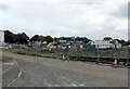
Building site at Dunipace
New development of house building at Rosebank
Image: © Eirian Evans
Taken: 10 Sep 2021
0.03 miles
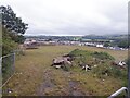
4
Building site, Rosebank
Myot Hill in the background
Image: © Richard Webb
Taken: 11 Sep 2020
0.06 miles
5
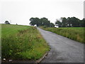
Path to Dunipace
What appears to be a grassed over road is signposted by the Scottish Rights of Way Society.
Image: © Richard Webb
Taken: 20 Mar 2012
0.06 miles

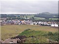
8
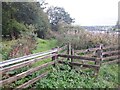
Footpath meeting Plean Road
The other end of the footpath is 440 metres SSW of here, at Stirling Road.
Image: © Lairich Rig
Taken: 5 Jul 2008
0.12 miles
9
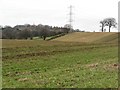
Newly fertilised field, Rosebank
The muckspreader has been at work.
Image: © Richard Webb
Taken: 11 Feb 2007
0.14 miles
10
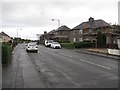
Stirling Street
Housing stock renovations taking place in Rosebank.
Image: © Richard Webb
Taken: 18 Oct 2010
0.17 miles