IMAGES TAKEN NEAR TO
DENNY, FK6 6BL
Introduction
This page details the photographs taken nearby to FK6 6BL by members of the Geograph project.
The Geograph project started in 2005 with the aim of publishing, organising and preserving representative images for every square kilometre of Great Britain, Ireland and the Isle of Man.

There are currently over 7.5m images from over14,400 individuals and you can help contribute to the project by visiting https://www.geograph.org.uk
Image Map
Images are licensed for reuse under creativecommons.org/licenses/by-sa/2.0
Notes
- Clicking on the map will re-center to the selected point.
- The higher the marker number, the further away the image location is from the centre of the postcode.
Image Listing (11 Images Found)
Images are licensed for reuse under creativecommons.org/licenses/by-sa/2.0
Image
Details
Distance
1
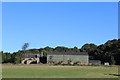
View to works beside the River Carron
The photograph was taken from Denovan Road. The buildings visible in this photo lie between the road and the river, and belong to the works that are described as being crossed by a public right of way in Image
For a different view of the area on the right of the photo, see Image
Image: © Lairich Rig
Taken: 1 Mar 2010
0.03 miles
2
Sign for public right of way
The sign, which stands alongside Denovan Road, reads:
"Public Right of Way to
Falkirk Road 500m"
The footpath crosses an industrial site (see Image). On the other side of the road, the way ahead is immediately blocked by a tall metal barrier; despite the fact that the route is a footpath, and not a road, a notice there states that those who wish to use the footpath should "sound their horn", and wait to be escorted through.
The buildings visible in the background are Image; see also Image
Image: © Lairich Rig
Taken: 1 Mar 2010
0.10 miles
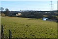
4
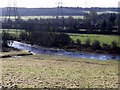
River Carron
Running high viewed from Denovan Road. A new mobile home park can be glimpsed through trees on the Denny side.
Image: © Robert Murray
Taken: 10 Feb 2011
0.17 miles
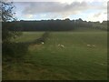
6
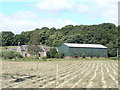
Field beside Kirkland Farm
For the farm buildings themselves, see Image and Image The area of woodland behind the farm is Rasp Wood; see also Image
Image: © Lairich Rig
Taken: 1 Mar 2010
0.21 miles
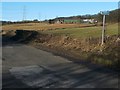
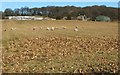
8

Woodyett
Small field between the old road and a new alignment east of Denny. There is a residential caravan park nearby (Beech Tree Park Homes).
Image: © Richard Webb
Taken: 8 Nov 2009
0.22 miles
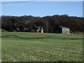
9

Denovan Road
Looking towards Denovan with the landmark spire of the former Denovan church rising above the trees. See http://www.scottishchurches.org.uk/sites/site/id/7690/name/Dunipace+North+Parish+Church+Dunipace+Central for information on this fine building and Image for a closer view.
Image: © Robert Murray
Taken: 10 Feb 2011
0.23 miles