IMAGES TAKEN NEAR TO
DENNY, FK6 5LH
Introduction
This page details the photographs taken nearby to FK6 5LH by members of the Geograph project.
The Geograph project started in 2005 with the aim of publishing, organising and preserving representative images for every square kilometre of Great Britain, Ireland and the Isle of Man.

There are currently over 7.5m images from over14,400 individuals and you can help contribute to the project by visiting https://www.geograph.org.uk
Image Map (Loading...)


Getting Data...Please wait
Leaflet Map data © OpenStreetMap
Images are licensed for reuse under creativecommons.org/licenses/by-sa/2.0
Notes
- Clicking on the map will re-center to the selected point.
- The higher the marker number, the further away the image location is from the centre of the postcode.
Image Listing (14 Images Found)
Images are licensed for reuse under creativecommons.org/licenses/by-sa/2.0
Image
Details
Distance
2
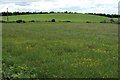
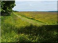
Field beside Drove Loan
Of the two fields visible here, the more distant one has, at its highest point, a small modern structure; in this photograph, that structure is positioned centrally on the skyline.
The area around that structure is of archaeological interest, and, in 1996, was granted legal protection as a scheduled monument. See https://canmore.org.uk/site/47007/wheatlands (at Canmore) for details of the traces of a prehistoric settlement found there; the settlement was surrounded by an oval enclosure.
In the report just cited, an OS representative (a ground-based observer) states, in 1974, that no traces are visible. However, at the time of submission, the outline of the oval enclosure can still be discerned on satellite imagery; for such an image, which I have annotated to show the outline of the enclosure, see https://www.google.com/maps/d/viewer?mid=1XT6lTkLb5_Vy9C6vCMSSERxzUww&ll=56.005130964554866%2C-3.8994382662010594&z=19
For a more distant view, and for a discussion of Drove Loan itself (and its name in particular), see Image
Image: © Lairich Rig
Taken: 14 Jun 2010
0.14 miles
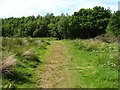
3
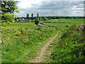
Footpath from Chacefield Wood
The footpath leads towards a road called Drove Loan, which is visible in the background, on the left; that road is mentioned in John Mitchell's article "The Legacy of the Highland Drovers", in issue 76 (Summer 2009) of "Scottish Local History" magazine.
In the article, Mitchell writes that "in the past signifying a common right of passage for livestock, the term 'Loan' in a street name is always worth investigation, though it is likely that most have their origin in the lanes used by urban milk cows as they made the daily trek from their back-yard byres to the communal pastures on the outskirts of town. Nevertheless, some can be traced back to the Highland drovers, for a study based on old documents and maps covering the Falkirk district identified a number of 'Drove Loans' specifically named as such. One of these – the last stretch of a once well-trodden drove way from the Carron Valley heading towards Bonnybridge – has been adopted unchanged for the present-day surfaced road".
The buildings in the background, on the left, are Home Farm Holiday Cottages.
Near the right-hand edge of the photograph, a small modern structure is just visible on a raised area at the far side of the field. That structure lies within the bounds of an ancient enclosure, which is protected by law as a scheduled monument. That area and its prehistoric remains lie outside the grid square from which the present photograph was taken, but they are shown and discussed separately in Image
Only a few metres from the photographer's position, some much more recent ruins stand just to the right (the west) of the footpath: Image
For a view in the opposite direction along the footpath, back towards the woods, see Image
Image: © Lairich Rig
Taken: 24 May 2010
0.16 miles
5
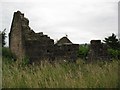
North Bonnyfield (ruin)
See www.geograph.org.uk/photo/1903072 for some great info.
Image: © Texas Radio and The Big Beat
Taken: 24 Jul 2010
0.18 miles
6
The remains of North Bonnyfield
These ruined buildings are shown but not named on the first-edition OS map (c.1865); on the second-edition map (c.1899), they are named North Bonnyfield. See also Image
The ruins stand just to the west of a well-used Image to Drove Loan; see that link for background details of the present photograph.
Image: © Lairich Rig
Taken: 24 May 2010
0.19 miles
7
Field beside Chacefield Wood
The photograph shows part of the area that lies between Chacefield Wood, whose southern edge can be seen on the left, and Drove Loan (on whose name, see Image).
Some of the chimneys of Grangemouth Refinery are just visible in the distance, near the centre of the image. To the right, some tower blocks in Falkirk can also be seen.
The photograph was taken from the point where the path shown in Image enters the woods.
Image: © Lairich Rig
Taken: 14 Jun 2010
0.21 miles
8
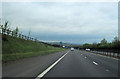
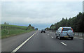
M876 approaching junction 1 signs
Embankment on side of road positions it on map
Image: © John Firth
Taken: 13 May 2012
0.21 miles
9
Footpath to Chacefield Wood
The footpath leads from Drove Loan to the woods. For a view in the opposite direction, and for further details, see Image
Image: © Lairich Rig
Taken: 14 Jun 2010
0.24 miles
10
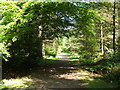
Footpath in Chacefield Wood
There are several woodland walks in Chacefield Wood, and the Wood itself can be accessed from various points, e.g., from Head of Muir to the west, from Drove Loan to the south, or from the old railway line path to the east.
Image: © Lairich Rig
Taken: 6 Jun 2007
0.24 miles