IMAGES TAKEN NEAR TO
DENNY, FK6 5JX
Introduction
This page details the photographs taken nearby to FK6 5JX by members of the Geograph project.
The Geograph project started in 2005 with the aim of publishing, organising and preserving representative images for every square kilometre of Great Britain, Ireland and the Isle of Man.

There are currently over 7.5m images from over14,400 individuals and you can help contribute to the project by visiting https://www.geograph.org.uk
Image Map
Images are licensed for reuse under creativecommons.org/licenses/by-sa/2.0
Notes
- Clicking on the map will re-center to the selected point.
- The higher the marker number, the further away the image location is from the centre of the postcode.
Image Listing (7 Images Found)
Images are licensed for reuse under creativecommons.org/licenses/by-sa/2.0
Image
Details
Distance
1
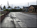
Drove Loan joining Denny Road (A872) at Head of Muir
Looking westward.
Image: © Peter Wood
Taken: 1 Oct 2017
0.07 miles
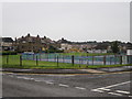
2
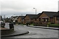
Chacefield Wood
New houses in Head of Muir.
Image: © Richard Webb
Taken: 11 Feb 2007
0.11 miles
3
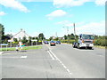
Head of Muir
Looking north along the main street of the village that used to be called Muirhead.
Image: © James Allan
Taken: 13 Jul 2006
0.12 miles
4
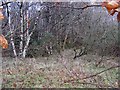
Chacefield Wood
A keek through the beech hedge at the rest of the wood, without the houses built on it.
Image: © Richard Webb
Taken: 11 Feb 2007
0.15 miles
6
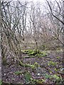
Woodland, Head of Muir
Old industrial land now covered in young woodland. Opposite Denny High School.
Image: © Richard Webb
Taken: 11 Feb 2007
0.22 miles
7
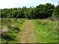
Footpath to Chacefield Wood
The footpath leads from Drove Loan to the woods. For a view in the opposite direction, and for further details, see Image
Image: © Lairich Rig
Taken: 14 Jun 2010
0.24 miles