IMAGES TAKEN NEAR TO
Broadside Court, DENNY, FK6 5GZ
Introduction
This page details the photographs taken nearby to Broadside Court, FK6 5GZ by members of the Geograph project.
The Geograph project started in 2005 with the aim of publishing, organising and preserving representative images for every square kilometre of Great Britain, Ireland and the Isle of Man.

There are currently over 7.5m images from over14,400 individuals and you can help contribute to the project by visiting https://www.geograph.org.uk
Image Map
Images are licensed for reuse under creativecommons.org/licenses/by-sa/2.0
Notes
- Clicking on the map will re-center to the selected point.
- The higher the marker number, the further away the image location is from the centre of the postcode.
Image Listing (7 Images Found)
Images are licensed for reuse under creativecommons.org/licenses/by-sa/2.0
Image
Details
Distance

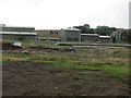
4
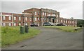
Broadside water treatment works
The road here looks like going into the water works but there is a left turn into Broadside farm and a right turn northwards to the Denny - Fintry road (B818). There is a large water treatment complex behind the fences, part of which may be redundant, superseded by a modern installation further down the hill.
Image: © Robert Murray
Taken: 28 Aug 2010
0.13 miles
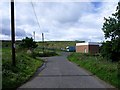
6
Carron Valley Water Treatment Works
New waterworks buildings.
Image: © Richard Webb
Taken: 10 Sep 2011
0.22 miles
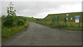
7
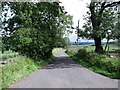
The road to Crummocksteps
And beyond that exotic metropolis (pop. 4) lies Fankerton.
Image: © Robert Murray
Taken: 28 Aug 2010
0.25 miles