IMAGES TAKEN NEAR TO
Abbotsgrange Road, GRANGEMOUTH, FK3 9JZ
Introduction
This page details the photographs taken nearby to Abbotsgrange Road, FK3 9JZ by members of the Geograph project.
The Geograph project started in 2005 with the aim of publishing, organising and preserving representative images for every square kilometre of Great Britain, Ireland and the Isle of Man.

There are currently over 7.5m images from over14,400 individuals and you can help contribute to the project by visiting https://www.geograph.org.uk
Image Map
Images are licensed for reuse under creativecommons.org/licenses/by-sa/2.0
Notes
- Clicking on the map will re-center to the selected point.
- The higher the marker number, the further away the image location is from the centre of the postcode.
Image Listing (6 Images Found)
Images are licensed for reuse under creativecommons.org/licenses/by-sa/2.0
Image
Details
Distance
1
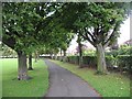
Zetland Park
A horse chestnut avenue beside Abbotsgrange Road.
Image: © Richard Webb
Taken: 4 Sep 2009
0.05 miles
2
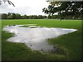
Zetland Park
Rain flooded area of the park in the middle of Grangemouth. A more serious flood risk is posed by the adjacent Grange Burn, but the excess water is usually safely diverted into the Avon long before it reaches the town.
Image: © Richard Webb
Taken: 4 Sep 2009
0.09 miles

4
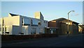
Health Centre, Grangemouth
On Kersiebank Avenue
Image: © Tom Sargent
Taken: 28 Dec 2008
0.16 miles
5
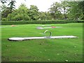
Crazy golf, Zetland Park
Forget windmills, this one has to be as near indestructible as possible. A strangely minimalist installation.
Image: © Richard Webb
Taken: 4 Sep 2009
0.22 miles
6
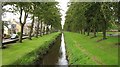
Grange Burn
An obvious cause of flooding, the burn is canalised with embankments running its length. Much of its water no longer flows this way at all, being diverted through a deep channel into the Avon before it gets near Grangemouth.
Image: © Richard Webb
Taken: 4 Sep 2009
0.25 miles