IMAGES TAKEN NEAR TO
Ward Avenue, FALKIRK, FK2 9UL
Introduction
This page details the photographs taken nearby to Ward Avenue, FK2 9UL by members of the Geograph project.
The Geograph project started in 2005 with the aim of publishing, organising and preserving representative images for every square kilometre of Great Britain, Ireland and the Isle of Man.

There are currently over 7.5m images from over14,400 individuals and you can help contribute to the project by visiting https://www.geograph.org.uk
Image Map
Images are licensed for reuse under creativecommons.org/licenses/by-sa/2.0
Notes
- Clicking on the map will re-center to the selected point.
- The higher the marker number, the further away the image location is from the centre of the postcode.
Image Listing (10 Images Found)
Images are licensed for reuse under creativecommons.org/licenses/by-sa/2.0
Image
Details
Distance
1
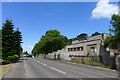
Salmon Inn Service Reservoir, Polmont
Wikipedia: "Service reservoirs store fully treated potable water close to the point of distribution... [They] perform several functions, including ensuring sufficient head of water in the water distribution system and providing water capacity to even out peak demand from consumers,"
Image: © Tim Heaton
Taken: 4 Jul 2018
0.12 miles
2
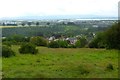
Rural view, Redding
The River Forth can be seen in the distance.
Image: © Robert Murray
Taken: 28 Jul 2015
0.14 miles
3
Redding is not a one horse town.
Main Street Redding. Today a muddy horse paddock, but on the edge of a steep slope, the developers must be hovering.
Image: © Richard Webb
Taken: 12 Dec 2005
0.15 miles
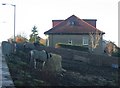
4
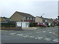
Salmon Inn Road, Polmont
Looking north west.
Image: © JThomas
Taken: 21 Jun 2017
0.17 miles
5
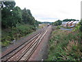
Polmont Junction
The line at the bottom of the picture and curving away left in the background is the main Edinburgh and Glasgow line via Falkirk High. The Class 170 diesel unit is crossing over to take the line to the right, which leads to Stirling and Dunblane via Falkirk Grahamston. Polmont, conveniently placed between two of Scotland's major cities with good rail and motorway links to both, has in the past few years seen something of a housing boom and the empty area to the left of the train, once occupied by an engine shed and sidings, was earmarked early in 2008 for further housing development.
Image: © A-M-Jervis
Taken: 30 Aug 2007
0.19 miles
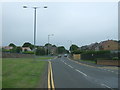
7
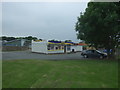
Shop and takeaway off Salmon Inn Road, Polmont
Image: © JThomas
Taken: 21 Jun 2017
0.21 miles
8
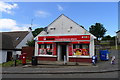
Convenience store, Redding
usave: United Wholesale Ltd., with 200 stores in Scotland
Image: © Tim Heaton
Taken: 4 Jul 2018
0.23 miles
9
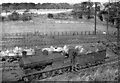
Ex-NBR 0-6-0 at Polmont
View northward: Edinburgh (left) - Glasgow (right) ex-NBR main line. Coming off Shed is one of the 168 NB Holmes class C (LNER J36) general purpose 0-6-0s, No. 65275, which was built as NB No. 180 in 1/1893, LNER No. 9180 (No. 5275 from 1946) and survived until 12/62. (It was not one of the 25 which served in France in World War One and acquired names).
Image: © Ben Brooksbank
Taken: 27 Sep 1957
0.23 miles
10

Union Canal at Redding
Following the towpath of the Union Canal westwards in Redding towards Bridge No. 55.
Image: © Chris Heaton
Taken: 9 Aug 2009
0.24 miles