IMAGES TAKEN NEAR TO
Stenhouse Road, FALKIRK, FK2 8DR
Introduction
This page details the photographs taken nearby to Stenhouse Road, FK2 8DR by members of the Geograph project.
The Geograph project started in 2005 with the aim of publishing, organising and preserving representative images for every square kilometre of Great Britain, Ireland and the Isle of Man.

There are currently over 7.5m images from over14,400 individuals and you can help contribute to the project by visiting https://www.geograph.org.uk
Image Map
Images are licensed for reuse under creativecommons.org/licenses/by-sa/2.0
Notes
- Clicking on the map will re-center to the selected point.
- The higher the marker number, the further away the image location is from the centre of the postcode.
Image Listing (11 Images Found)
Images are licensed for reuse under creativecommons.org/licenses/by-sa/2.0
Image
Details
Distance
1
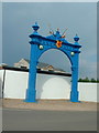
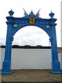
Carron Works, Falkirk
This cast-iron gateway was made by the Grahamston Iron Foundry for the Edinburgh International Exhibition in 1886. Following the exhibition, it stood at the entrance to the Grahamston foundry until 2001 at which time it underwent extensive renovation before being moved to its present location on the banks of the River Carron at the site of the famous Carron Iron Works. The present occupiers, Carron Phoenix, kindly gave permission for it to be erected at the entrance to their factory. It is believed to be the world's largest cast iron gateway (information by John Reid).
Image: © Oliver Dixon
Taken: 10 May 2004
0.04 miles
3
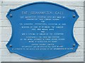
Grahamston Gate information panel, Carron-Phoenix Works
Image: © kim traynor
Taken: 12 Aug 2010
0.05 miles
4
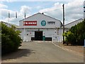
New Carron Works
Like a Phoenix rising from the ashes of the old place next door. Good to see the historical name preserved.
Image: © Robert Murray
Taken: 17 Jul 2014
0.05 miles
5
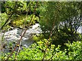
River Carron, broken weir
With the demise of the need for water power in the nearby Carron Iron Works the weirs on the river associated with supplying it were broken to allow Salmon access to the upper reaches of the river. See also Image
Image: © Robert Murray
Taken: 17 Jul 2014
0.08 miles
6
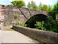
Carron Viaduct
Built in 1860 this bridge carried a mineral railway over the river and into the Carron Iron Works.
Image: © Robert Murray
Taken: 17 Jul 2014
0.15 miles
10
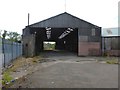
Carron Works
A remaining shed of the Carron Iron Works site.
Image: © Robert Murray
Taken: 17 Jul 2014
0.24 miles