IMAGES TAKEN NEAR TO
Seaforth Road, FALKIRK, FK2 7TP
Introduction
This page details the photographs taken nearby to Seaforth Road, FK2 7TP by members of the Geograph project.
The Geograph project started in 2005 with the aim of publishing, organising and preserving representative images for every square kilometre of Great Britain, Ireland and the Isle of Man.

There are currently over 7.5m images from over14,400 individuals and you can help contribute to the project by visiting https://www.geograph.org.uk
Image Map
Images are licensed for reuse under creativecommons.org/licenses/by-sa/2.0
Notes
- Clicking on the map will re-center to the selected point.
- The higher the marker number, the further away the image location is from the centre of the postcode.
Image Listing (5 Images Found)
Images are licensed for reuse under creativecommons.org/licenses/by-sa/2.0
Image
Details
Distance
1
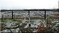
Land awaiting development, Bankside
Looking southwards off Davids Loan to a flat expanse of land which appears to be being prepared for building.
Image: © Richard Webb
Taken: 15 Jan 2010
0.12 miles
2
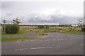
Land awaiting development, Bankside
This brownfield land was once a large industrial site. There is a supermarket distribution warehouse built on part of the site, background.
Image: © Richard Webb
Taken: 13 Sep 2017
0.14 miles
3
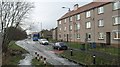
Langlees
Flats at the end of Davids Loan.
Image: © Richard Webb
Taken: 15 Jan 2010
0.20 miles
4
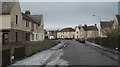
Cobblebrae Crescent
Residential street, Bainsford.
Image: © Richard Webb
Taken: 15 Jan 2010
0.23 miles
5
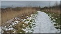
Woodland path, Langlees
Icy path in an area of woodland at the end of Davids Loan. A thaw was in progress, and as usual areas of compacted snow had turned to ice.
Image: © Richard Webb
Taken: 15 Jan 2010
0.24 miles