IMAGES TAKEN NEAR TO
Keir, DUNBLANE, FK15 9NT
Introduction
This page details the photographs taken nearby to FK15 9NT by members of the Geograph project.
The Geograph project started in 2005 with the aim of publishing, organising and preserving representative images for every square kilometre of Great Britain, Ireland and the Isle of Man.

There are currently over 7.5m images from over14,400 individuals and you can help contribute to the project by visiting https://www.geograph.org.uk
Image Map
Images are licensed for reuse under creativecommons.org/licenses/by-sa/2.0
Notes
- Clicking on the map will re-center to the selected point.
- The higher the marker number, the further away the image location is from the centre of the postcode.
Image Listing (6 Images Found)
Images are licensed for reuse under creativecommons.org/licenses/by-sa/2.0
Image
Details
Distance
1
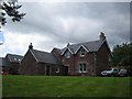
Hillside Farm Steading
Part of the original Hillside Farm which was converted into houses in 2000
Image: © Dave Coustick
Taken: 25 Jun 2006
0.05 miles
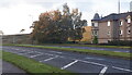
2
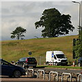
Field, Dunblane
Not yet built upon but one lane of the old A9 was closed and there was some Heras fencing up. Something may be happening.
Image: © Richard Webb
Taken: 2 Aug 2021
0.19 miles
3
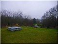
Covered reservoir, Dunblane
Unfortified, therefore almost certainly redundant, it occupies a hill top which was also once occupied by a Roman camp. Now this is an informal green space amongst modern housing.
Image: © Richard Webb
Taken: 16 Dec 2016
0.22 miles
4
Covered reservoir, Dunblane
Hill top to the west of the town centre in an area of infill housing inside the bypass. The reservoir must be disused as there is no fencing.
Image: © Richard Webb
Taken: 16 Dec 2016
0.22 miles
5
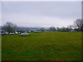
Stirling Road, Dunblane
B8033, once the A9.
Image: © Richard Webb
Taken: 9 Oct 2020
0.23 miles
6
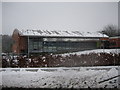
Dunblane in Winter: The Dunblane Centre
Image: © Robert Smallman
Taken: 25 Feb 2010
0.25 miles