IMAGES TAKEN NEAR TO
Keir, DUNBLANE, FK15 9NS
Introduction
This page details the photographs taken nearby to FK15 9NS by members of the Geograph project.
The Geograph project started in 2005 with the aim of publishing, organising and preserving representative images for every square kilometre of Great Britain, Ireland and the Isle of Man.

There are currently over 7.5m images from over14,400 individuals and you can help contribute to the project by visiting https://www.geograph.org.uk
Image Map
Images are licensed for reuse under creativecommons.org/licenses/by-sa/2.0
Notes
- Clicking on the map will re-center to the selected point.
- The higher the marker number, the further away the image location is from the centre of the postcode.
Image Listing (11 Images Found)
Images are licensed for reuse under creativecommons.org/licenses/by-sa/2.0
Image
Details
Distance
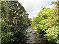
1
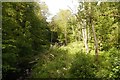
Wharry Burn
At the foot of the Kippenrait Glen.
Image: © Richard Webb
Taken: 5 Jun 2018
0.14 miles
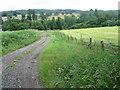
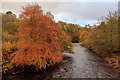
6
Upstream view, Allan Water
Autumnal colour is starting to emerge on the trees lining the river.
Image: © Alan O'Dowd
Taken: 24 Sep 2022
0.22 miles
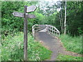
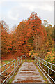
7
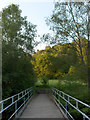
Footbridge, Allan Water
Woodland below Drumdruills from half way across Allan Water.
Image: © Andrew Smith
Taken: 14 Jun 2006
0.22 miles
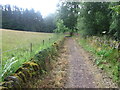
10
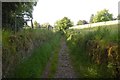
Darn Road
A sunken lane with an uneven rocky surface. Once an attempt was made to stop its use. Walls were built across the lane, but always torn down soon after - by the builders.
Image: © Richard Webb
Taken: 5 Jun 2018
0.24 miles