IMAGES TAKEN NEAR TO
Braco, DUNBLANE, FK15 9LN
Introduction
This page details the photographs taken nearby to FK15 9LN by members of the Geograph project.
The Geograph project started in 2005 with the aim of publishing, organising and preserving representative images for every square kilometre of Great Britain, Ireland and the Isle of Man.

There are currently over 7.5m images from over14,400 individuals and you can help contribute to the project by visiting https://www.geograph.org.uk
Image Map
Images are licensed for reuse under creativecommons.org/licenses/by-sa/2.0
Notes
- Clicking on the map will re-center to the selected point.
- The higher the marker number, the further away the image location is from the centre of the postcode.
Image Listing (7 Images Found)
Images are licensed for reuse under creativecommons.org/licenses/by-sa/2.0
Image
Details
Distance
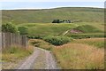
1
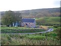
Greenscares
Now rebuilt and a home again. The house is just south of the gridline, but all the land before it belongs to this square.
Image: © Richard Webb
Taken: 8 Oct 2006
0.02 miles
3
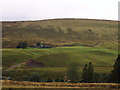
Glenuchorn Farm
Situated above the River Knaik, a hill farm
Image: © Calum McRoberts
Taken: 8 Sep 2005
0.08 miles