IMAGES TAKEN NEAR TO
Sinclair Street, DUNBLANE, FK15 0AH
Introduction
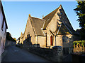
This page details the photographs taken nearby to Sinclair Street, FK15 0AH by members of the Geograph project.
The Geograph project started in 2005 with the aim of publishing, organising and preserving representative images for every square kilometre of Great Britain, Ireland and the Isle of Man.

There are currently over 7.5m images from over14,400 individuals and you can help contribute to the project by visiting https://www.geograph.org.uk
Image Map
Images are licensed for reuse under creativecommons.org/licenses/by-sa/2.0
Notes
- Clicking on the map will re-center to the selected point.
- The higher the marker number, the further away the image location is from the centre of the postcode.
Image Listing (484 Images Found)
Images are licensed for reuse under creativecommons.org/licenses/by-sa/2.0
Image
Details
Distance
1
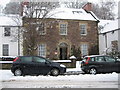
Dunblane in Winter: Scottish Churches House
Ecumenical Study Centre in Dunblane.
Image: © Robert Smallman
Taken: 25 Feb 2010
0.01 miles
2
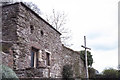
Out-buildings used by Churches' House as a chapel
Image: © Elliott Simpson
Taken: Unknown
0.02 miles
3
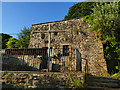
Old Churches House, Dunblane - the old chapel
This small chapel behind Old Churches House Image is not regularly open to the public, but customers of the restaurant may ask to borrow the key. It has an interesting history: described non-comittally by Historic Scotland in the listing (category B, LB 26380) as a 'vaulted chamber' because it is unclear whether it was originally a chapel, ice-house or served some other purpose. But it clearly formed part of a larger building, possibly the Archdeacon's manse of the 16th century. It was restored to religious use when the nearby buildings became a church conference centre in the 1960s and is still occasionally used for worship. See Image for the inside and Image for a 1972 view, not long after its restoration.
Image: © Stephen Craven
Taken: 27 Jun 2019
0.02 miles
4
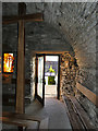
Old Churches House, Dunblane - the old chapel (interior)
See Image for the outside, and a brief history.
Image: © Stephen Craven
Taken: 27 Jun 2019
0.02 miles
5
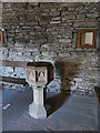
Old Churches House, Dunblane - the old chapel - font
See Image for the outside, and a brief history.
Image: © Stephen Craven
Taken: 27 Jun 2019
0.02 miles
6
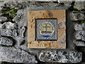
Old Churches House, Dunblane - the old chapel - inside plaque
The plaque records the first World Council of Churches in Amsterdam in 1948; its presence here in Scotland represents the chapel's role as an ecumenical centre. See Image for the outside, and a brief history.
Image: © Stephen Craven
Taken: 27 Jun 2019
0.02 miles
7
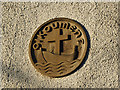
Old Churches House, Dunblane - the old chapel - outside plaque
The plaque with its Greek word (oukoumene, meaning household) is the symbol of the World Council of Churches. See Image for context and a history of the building.
Image: © Stephen Craven
Taken: 27 Jun 2019
0.02 miles
8
St Blane, Dunblane: August 2014
Also see https://en.wikipedia.org/wiki/St_Blane%27s_Church,_Dunblane
Image: © Basher Eyre
Taken: 12 Aug 2014
0.02 miles
9
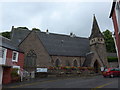
St Blane's church, Dunblane
A church named after the city's patron saint. It is listed category B (LB26386), and the listing explains its denominational history: built in 1853-54 as a Free Church, becoming Church of Scotland in 1929, and taking the present name in 1951 when it amalgamated with the former Leighton Church.
Image: © Stephen Craven
Taken: 27 Jun 2019
0.02 miles
10
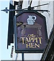
Sign for The Tappit Hen, Dunblane
The form of pewter measure known as the tappit hen is peculiar to Scotland. The name is applied to measures characterised by having a body comprising a small straight-sided top section, a larger straight-sided bottom section and a curved section between. Typically, the measure has a domed lid that is raised by means of an erect thumbpiece located on a hinge at the top of the handle. (The early evolution of the tappit hen. Peter Spencer Davies, George Dalgleish and David Lamb. Proc Soc Antiq Scot 141 (2011), 279–292.)
Image: © Richard Sutcliffe
Taken: 24 May 2018
0.02 miles