IMAGES TAKEN NEAR TO
Fairlie Street, FALKIRK, FK1 4NH
Introduction
This page details the photographs taken nearby to Fairlie Street, FK1 4NH by members of the Geograph project.
The Geograph project started in 2005 with the aim of publishing, organising and preserving representative images for every square kilometre of Great Britain, Ireland and the Isle of Man.

There are currently over 7.5m images from over14,400 individuals and you can help contribute to the project by visiting https://www.geograph.org.uk
Image Map
Images are licensed for reuse under creativecommons.org/licenses/by-sa/2.0
Notes
- Clicking on the map will re-center to the selected point.
- The higher the marker number, the further away the image location is from the centre of the postcode.
Image Listing (16 Images Found)
Images are licensed for reuse under creativecommons.org/licenses/by-sa/2.0
Image
Details
Distance
1
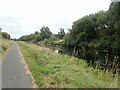
Towpath along the Forth and Clyde Canal
Image: © Eirian Evans
Taken: 10 Sep 2021
0.01 miles
2
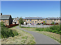
Path off the Forth and Clyde Canal
The path heads into a housing estate on the way to Camelon railway station.
Image: © Stephen Craven
Taken: 27 Jun 2019
0.04 miles
3
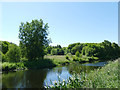
Open space by the Forth and Clyde Canal
What was once the site of the Camelon chemical works on the south bank of the canal near Falkirk is now a woodland with open spaces.
Image: © Stephen Craven
Taken: 27 Jun 2019
0.04 miles
4
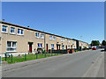
Housing on Fairlie Drive
Probably post-War council housing.
Image: © Stephen Craven
Taken: 27 Jun 2019
0.14 miles
5
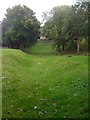
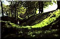
Antonine Wall at Watling Lodge
The ditch and ramparts which are the remains of the Antonine Wall
Image: © Darrin Antrobus
Taken: 25 Sep 2012
0.16 miles
6
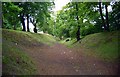
Ditch of the Antonine Wall at Watling Lodge
This view is intended to complement an earlier photo, a view in the opposite direction: Image; the description accompanying that photo provides further information.
Watling Lodge was the site of a gate through the Antonine Wall; the gate was protected by a fortlet.
The best-preserved portion of the ditch of the Antonine Wall lies near a present-day house called Watling Lodge. The nomination document proposing World Heritage status for the Antonine Wall says of this part of the wall:
"To the east of the house the ditch preserves almost its original profile of 12m wide by 4.5m deep, while the outer mound is particularly sharp because of the steep slope to the north. The rampart base is not visible, though it has been located through excavation. Generally, to the east of Watling Lodge the rampart was mostly constructed of clay(*); to the west it was of turf."
[(*) That is to say, earth (as opposed to turfs) revetted with clay: "although it is commonly stated that the Antonine Wall was built of turf, a considerable part of it was actually built of earth revetted by clay cheeks; turf cheeks are also known. Most of the eastern 16km (10 miles) from Watling Lodge to Bo'ness was constructed in this manner, although turf was used in certain places. Some earthen sections have also been recorded at the west end of the Wall" – David J. Breeze in his book "The Antonine Wall" (2006).]
In this view, the rampart itself is on the left; as at other parts of the Antonine Wall, the material that was excavated when digging the ditch was tipped out on the northern side of the ditch (the right-hand side in this photo), forming the so-called upcast mound (or outer mound).
The Antonine Wall was granted World Heritage status in 2008, becoming incorporated into the trans-national "Frontiers of the Roman Empire" World Heritage Site.
Image: © Lairich Rig
Taken: Unknown
0.17 miles
7
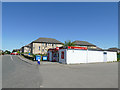
U-Save, Carmuirs Street
A convenience store.
Image: © Stephen Craven
Taken: 27 Jun 2019
0.18 miles
8
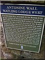
Antonine Wall Info from Historic Scotland
Plaque at Watling Lodge
Image: © Darrin Antrobus
Taken: 25 Sep 2012
0.18 miles
9
Antonine's Wall at Watling Lodge
Antonine's Wall running across central Scotland from the Forth to the Clyde was built in 142AD and is 37 miles long. It marked the northern frontier of the Roman Empire but was soon abandoned. The photo shows the ditch in advance of the wall with upcast mound to the left and ramparts to the right.Since it was built of turf on stone foundations much of the wall has been eroded but sections here also at Rough Castle and over Barr Hill are well preserved. It is now listed as a World Heritage Site.
Image: © ronnie leask
Taken: Unknown
0.18 miles
10

Forth and Clyde Canal
A bottle of Becks floats serenely by on the Forth and Clyde Canal. Nearby somewone was fly fishing. The woodland on the far side looks wild and has probably grown on former industrial land.
Image: © Richard Webb
Taken: 23 Jun 2010
0.20 miles