Ditch of the Antonine Wall at Watling Lodge
Introduction
The photograph on this page of Ditch of the Antonine Wall at Watling Lodge by Lairich Rig as part of the Geograph project.
The Geograph project started in 2005 with the aim of publishing, organising and preserving representative images for every square kilometre of Great Britain, Ireland and the Isle of Man.

There are currently over 7.5m images from over 14,400 individuals and you can help contribute to the project by visiting https://www.geograph.org.uk
Ditch of the Antonine Wall at Watling Lodge
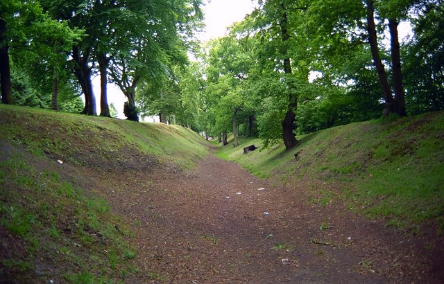
Image: © Lairich Rig Taken: Unknown
This view is intended to complement an earlier photo, a view in the opposite direction: Image; the description accompanying that photo provides further information. Watling Lodge was the site of a gate through the Antonine Wall; the gate was protected by a fortlet. The best-preserved portion of the ditch of the Antonine Wall lies near a present-day house called Watling Lodge. The nomination document proposing World Heritage status for the Antonine Wall says of this part of the wall: "To the east of the house the ditch preserves almost its original profile of 12m wide by 4.5m deep, while the outer mound is particularly sharp because of the steep slope to the north. The rampart base is not visible, though it has been located through excavation. Generally, to the east of Watling Lodge the rampart was mostly constructed of clay(*); to the west it was of turf." [(*) That is to say, earth (as opposed to turfs) revetted with clay: "although it is commonly stated that the Antonine Wall was built of turf, a considerable part of it was actually built of earth revetted by clay cheeks; turf cheeks are also known. Most of the eastern 16km (10 miles) from Watling Lodge to Bo'ness was constructed in this manner, although turf was used in certain places. Some earthen sections have also been recorded at the west end of the Wall" – David J. Breeze in his book "The Antonine Wall" (2006).] In this view, the rampart itself is on the left; as at other parts of the Antonine Wall, the material that was excavated when digging the ditch was tipped out on the northern side of the ditch (the right-hand side in this photo), forming the so-called upcast mound (or outer mound). The Antonine Wall was granted World Heritage status in 2008, becoming incorporated into the trans-national "Frontiers of the Roman Empire" World Heritage Site.
Images are licensed for reuse under creativecommons.org/licenses/by-sa/2.0
Image Location
Latitude
55.997899
Longitude
-3.824597