IMAGES TAKEN NEAR TO
FALKIRK, FK1 3AF
Introduction
This page details the photographs taken nearby to FK1 3AF by members of the Geograph project.
The Geograph project started in 2005 with the aim of publishing, organising and preserving representative images for every square kilometre of Great Britain, Ireland and the Isle of Man.

There are currently over 7.5m images from over14,400 individuals and you can help contribute to the project by visiting https://www.geograph.org.uk
Image Map
Images are licensed for reuse under creativecommons.org/licenses/by-sa/2.0
Notes
- Clicking on the map will re-center to the selected point.
- The higher the marker number, the further away the image location is from the centre of the postcode.
Image Listing (6 Images Found)
Images are licensed for reuse under creativecommons.org/licenses/by-sa/2.0
Image
Details
Distance
2
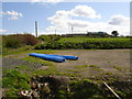
Beam Farm
Secluded in its own valley, it appears Beam Farm exudes a little tranquillity. However the local farmer explained his plans to convert this former Dairy farm into a pasture for horses were being thwarted by local government - due to a native flock of geese, farmers with many hectares of land are being prohibited from developing their land usage in case the geese are 'upset' at the change!
Image: © Raymond Okonski
Taken: 28 Apr 2007
0.02 miles
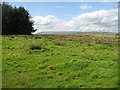
3
![Beam, Right of Way [3]](https://s2.geograph.org.uk/geophotos/02/77/23/2772330_08a2f3e7_120x120.jpg)
Beam, Right of Way [3]
The (on this occasion) muddy track to Beam.
Image: © Robert Murray
Taken: 13 Jan 2012
0.06 miles
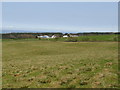
5
Grassland, Beam
A small plantation beside a grass field near Beam. This is a wintering ground for bean geese (Anser fabalis fabalis) and the farms here are under some pressure as to how the land is managed. Visiting is discouraged after September to reduce disturbance.
Image: © Richard Webb
Taken: 24 Aug 2009
0.18 miles
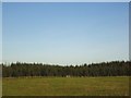
6
![Beam, Right of Way [2]](https://s1.geograph.org.uk/geophotos/02/77/23/2772329_e7566b81_120x120.jpg)
Beam, Right of Way [2]
Delightful stretch of the path.
Image: © Robert Murray
Taken: 13 Jan 2012
0.19 miles