IMAGES TAKEN NEAR TO
Parkend Crescent, FALKIRK, FK1 2EL
Introduction
This page details the photographs taken nearby to Parkend Crescent, FK1 2EL by members of the Geograph project.
The Geograph project started in 2005 with the aim of publishing, organising and preserving representative images for every square kilometre of Great Britain, Ireland and the Isle of Man.

There are currently over 7.5m images from over14,400 individuals and you can help contribute to the project by visiting https://www.geograph.org.uk
Image Map
Images are licensed for reuse under creativecommons.org/licenses/by-sa/2.0
Notes
- Clicking on the map will re-center to the selected point.
- The higher the marker number, the further away the image location is from the centre of the postcode.
Image Listing (12 Images Found)
Images are licensed for reuse under creativecommons.org/licenses/by-sa/2.0
Image
Details
Distance
2
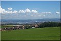
West end of Shieldhill village
View over Firth of Forth with Longannet Power Station and Ochil hills in the distance.
Image: © paul birrell
Taken: 22 Aug 2004
0.11 miles
3
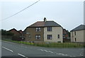
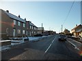
Shieldhill
Houses at the west of the village.
Image: © Richard Webb
Taken: 28 Nov 2005
0.15 miles
4

Shieldhill Convenience Store and Post Office
On Main Street.
Image: © JThomas
Taken: 21 Jun 2017
0.17 miles
5
Bus stop on Main Street, Shieldhill
Looking north east.
Image: © JThomas
Taken: 21 Jun 2017
0.18 miles
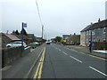
7
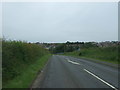
B8028 towards Shieldhill
Heading south east. The road drops down to the Westquarter Burn before rising sharply again into the village.
Image: © JThomas
Taken: 21 Jun 2017
0.19 miles
8
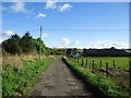
Shieldhill, Burnside
Track to Burnside Farm.
Image: © Robert Murray
Taken: 12 Sep 2012
0.20 miles
9
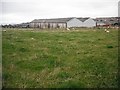
Wester Pirleyhill
Farm on the edge of Shieldhill.
Image: © Richard Webb
Taken: 14 Oct 2009
0.22 miles
10
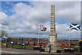
War Memorial, Main Street, Shieldhill
Inscription reads 'To the memory of the men of East and West Shieldhill and Summerhouse'.
Image: © Leslie Barrie
Taken: 4 May 2015
0.23 miles