IMAGES TAKEN NEAR TO
Keir Hardie Road, ALVA, FK12 5NA
Introduction
This page details the photographs taken nearby to Keir Hardie Road, FK12 5NA by members of the Geograph project.
The Geograph project started in 2005 with the aim of publishing, organising and preserving representative images for every square kilometre of Great Britain, Ireland and the Isle of Man.

There are currently over 7.5m images from over14,400 individuals and you can help contribute to the project by visiting https://www.geograph.org.uk
Image Map
Images are licensed for reuse under creativecommons.org/licenses/by-sa/2.0
Notes
- Clicking on the map will re-center to the selected point.
- The higher the marker number, the further away the image location is from the centre of the postcode.
Image Listing (6 Images Found)
Images are licensed for reuse under creativecommons.org/licenses/by-sa/2.0
Image
Details
Distance
1
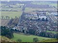
Keir Hardie Road, Alva
View from the hill road at the top of the zigzags.
Image: © Richard Webb
Taken: 7 Feb 2023
0.02 miles
2
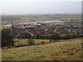
Track leading down from Silver Glen
Track leading down from Silver Glen, with extensive flooding of low-lying land to the south of the village of Alva.
Image: © John Chroston
Taken: 9 Jan 2015
0.09 miles
3
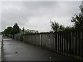
A vacant site, Alva
An open area which was once built upon.
Image: © Richard Webb
Taken: 17 Jun 2012
0.12 miles
4
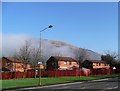
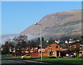
Housing at the east end of Alva
Low cloud still hanging on the edge of the Ochils.
Image: © Gordon Brown
Taken: 12 Feb 2008
0.15 miles
6
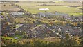
Alva from the Silver Glen
A view from the steep Ochils escarpment. The big building is Alva Academy.
Image: © Richard Webb
Taken: 5 Nov 2016
0.25 miles