IMAGES TAKEN NEAR TO
East Mains, MENSTRIE, FK11 7AW
Introduction
This page details the photographs taken nearby to East Mains, FK11 7AW by members of the Geograph project.
The Geograph project started in 2005 with the aim of publishing, organising and preserving representative images for every square kilometre of Great Britain, Ireland and the Isle of Man.

There are currently over 7.5m images from over14,400 individuals and you can help contribute to the project by visiting https://www.geograph.org.uk
Image Map
Images are licensed for reuse under creativecommons.org/licenses/by-sa/2.0
Notes
- Clicking on the map will re-center to the selected point.
- The higher the marker number, the further away the image location is from the centre of the postcode.
Image Listing (16 Images Found)
Images are licensed for reuse under creativecommons.org/licenses/by-sa/2.0
Image
Details
Distance
1
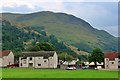
Houses at Forthvale
Myreton Hill and Craig Leith behind.
Image: © Oast House Archive
Taken: 4 Aug 2019
0.14 miles
2
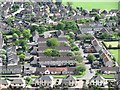
Forthvale
Housing in Menstrie. View from the slopes of Myreton Hill.
Image: © Richard Webb
Taken: 14 May 2011
0.15 miles
3
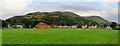
Menstrie Playing Field
Myreton Hill behind.
Image: © Oast House Archive
Taken: 4 Aug 2019
0.17 miles
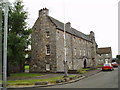
4
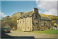
Menstrie Castle
Menstrie is one of the "Hillfoot Towns", a line of small towns on the southern edge of the Ochil Hills, east of Stirling. On the skyline behind the castle are Dumyat (famous viewpoint) and The Kips.
Image: © Colin Smith
Taken: Unknown
0.18 miles
5
Menstrie Castle
This Castle was built in the late 16th Century and was the birthplace of Sir William Alexander the founder of the Canadian province of Nova Scotia (New Scotland). The castle is not what you expect to find in the middle of a 1950's housing estate and indeed when the houses were being built it was threatened with demolition but was saved by the actor Moultrie Kelsall and restored. It is now in the care of the National Trust for Scotland.
Image: © Kevin Rae
Taken: 1 Aug 2005
0.19 miles
6
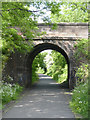
Bridge and cycle track
The bridge was built to carry the Tullibody to Menstrie road over the Alva Railway. Passenger services were withdrawn as early as 1954, but freight continued, the final traffic being to the Menstrie yeast factory which ceased around 2010. It has recently been converted into a cycle and footpath.
Image: © Alan Murray-Rust
Taken: 7 Jun 2013
0.19 miles
7
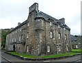
Castle Menstrie, Castle Road
Built as the home of William Alexander, 1st earl of Stirling and founder of the province of Nova Scotia. https://en.wikipedia.org/wiki/Sir_William_Alexander The building has been converted into residential apartments. https://en.wikipedia.org/wiki/Menstrie_Castle
Image: © kim traynor
Taken: 30 Aug 2013
0.19 miles
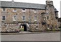
8
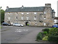
Menstrie Castle
Menstrie Castle is one of the five historical sites in the Clackmannanshire Tower Trail. It was built c.1560 as a manor house by the Alexander family, and was the birthplace of Sir William Alexander, a scholar and poet, who impressed King James VI with his learning. Menstrie Castle was occupied by the Abercrombie family from 1719 to 1924. By 1951 it was derelict. Restoration took place between 1957 and 1964. Menstrie Castle is a Category A listed building. https://www.britishlistedbuildings.co.uk/200332843-menstrie-castle-road-menstrie-castle-1-2-castle-court-alva#.WdUo_zGWw5s
Image: © G Laird
Taken: 3 Oct 2017
0.19 miles
10
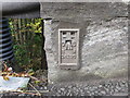
Ordnance Survey Flush Bracket G4299
This can be found on the roadside parapet of a bridge that crosses a former railway line at menstrie. The benchmark height is recorded as being 17.879 metres above sea level. For more detail see : http://www.bench-marks.org.uk/bm2693
Image: © Peter Wood
Taken: 30 Sep 2017
0.20 miles