IMAGES TAKEN NEAR TO
Keith Street, ALLOA, FK10 4NB

Introduction

This page details the photographs taken nearby to Keith Street, FK10 4NB by members of the Geograph project.

The Geograph project started in 2005 with the aim of publishing, organising and preserving representative images for every square kilometre of Great Britain, Ireland and the Isle of Man.

There are currently over 7.5m images from over14,400 individuals and you can help contribute to the project by visiting https://www.geograph.org.uk

Image Map


Images are licensed for reuse under creativecommons.org/licenses/by-sa/2.0
Notes
  • Clicking on the map will re-center to the selected point.
  • The higher the marker number, the further away the image location is from the centre of the postcode.

Image Listing (92 Images Found)

Images are licensed for reuse under creativecommons.org/licenses/by-sa/2.0
  • ...
Image
Details
Distance
1
Keith Street, Kincardine
Image: © Richard Webb Taken: 5 Nov 2016
0.02 miles
2
A876 North Approach Road in Kincardine
Image: © Mat Fascione Taken: 31 May 2016
0.03 miles
3
Kincardine on Forth
This is a view along Keith Street taken from the eastern end of Kincardine Bridge.
Image: © Paul McIlroy Taken: 6 Oct 2006
0.05 miles
4
Kincardine Bypass
Until recently all traffic coming from Fife to cross The Forth at Kincardine Bridge had to pass through the village but in 2004 a bypass was built, this picture shows where it meets up with the bridge, looking towards Longannet Power Station.
Image: © Paul McIlroy Taken: 6 Nov 2006
0.05 miles
5
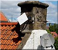
Satellite dishes
The square dish in this picture was known as a squarial it is a relic of the short-lived broadcaster BSB. http://en.wikipedia.org/wiki/British_Satellite_Broadcasting The other dish is a standard satellite antenna
Image: © Paul McIlroy Taken: 13 Jun 2008
0.06 miles
6
Silver Street
Residential street, Kincardine on Forth. Taken from a car park.
Image: © Richard Webb Taken: 18 Sep 2009
0.06 miles
7
House on Forth Street, Kincardine
Image: © JThomas Taken: 25 May 2017
0.07 miles
8
House in Excise Lane
One of many listed buildings in the old historic centre of Kincardine. An embedded stone bears the date 1749.
Image: © kim traynor Taken: 20 Jun 2013
0.07 miles
9
Merge in turn
The Fife approaches to the Kincardine Bridge, much quieter now the new bridge is open. The road from the left is the new Kincardine by-pass which takes Fife bound traffic to the east of Kincardine on Forth. Traffic heading to Clackmannanshire will probably be using the new bridge. Kincardine is very much quieter now than a few years earlier when all traffic using the crossing passed through the centre.
Image: © Richard Webb Taken: 18 Sep 2009
0.07 miles
10
Forth Street, Kincardine
Residential street used by National Cycle Route 76.
Image: © Richard Webb Taken: 15 Oct 2009
0.07 miles
  • ...