IMAGES TAKEN NEAR TO
Kincardine, ALLOA, FK10 4AX
Introduction
This page details the photographs taken nearby to FK10 4AX by members of the Geograph project.
The Geograph project started in 2005 with the aim of publishing, organising and preserving representative images for every square kilometre of Great Britain, Ireland and the Isle of Man.

There are currently over 7.5m images from over14,400 individuals and you can help contribute to the project by visiting https://www.geograph.org.uk
Image Map
Images are licensed for reuse under creativecommons.org/licenses/by-sa/2.0
Notes
- Clicking on the map will re-center to the selected point.
- The higher the marker number, the further away the image location is from the centre of the postcode.
Image Listing (5 Images Found)
Images are licensed for reuse under creativecommons.org/licenses/by-sa/2.0
Image
Details
Distance
1
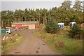
Stables
On the southern edge of Devilla Forest.
Image: © Paul McIlroy
Taken: 13 Nov 2006
0.08 miles
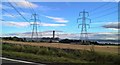
3
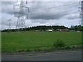
Pylons
Coming from Longannet Power Station.
Image: © Paul McIlroy
Taken: 25 May 2006
0.20 miles
4
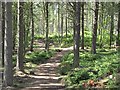
New path, Devilla Forest
A newly upgraded path on Culross Moor, now part of Devilla Forest. The path curves around to the south of a lochan and an older path, remembered from a past orienteering event, carries straight on to meet a logging road.
Image: © Richard Webb
Taken: 14 Jun 2009
0.22 miles
5
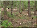
Forest
Devilla Forest. There has been a lot of rhododendron clearing recently. The next edition of the orienteering map will have a lot less green on it.
Image: © Richard Webb
Taken: 1 Jun 2011
0.25 miles