IMAGES TAKEN NEAR TO
Station Road, ALLOA, FK10 2NY
Introduction
This page details the photographs taken nearby to Station Road, FK10 2NY by members of the Geograph project.
The Geograph project started in 2005 with the aim of publishing, organising and preserving representative images for every square kilometre of Great Britain, Ireland and the Isle of Man.

There are currently over 7.5m images from over14,400 individuals and you can help contribute to the project by visiting https://www.geograph.org.uk
Image Map
Images are licensed for reuse under creativecommons.org/licenses/by-sa/2.0
Notes
- Clicking on the map will re-center to the selected point.
- The higher the marker number, the further away the image location is from the centre of the postcode.
Image Listing (22 Images Found)
Images are licensed for reuse under creativecommons.org/licenses/by-sa/2.0
Image
Details
Distance
1
Site of Cambus station, 1991
View westward, towards Stirling, and Alva branch to right: ex-NBR Stirling - Alloa etc., junction for Alva. At this time in 1991 the line was moribund, the station having been closed from 7/10/68, but the line has since been reopened for passengers between Stirling and Alloa since 15/5/08. [?] (Cf. Image]).
Image: © Ben Brooksbank
Taken: 5 Sep 1991
0.04 miles
2

Network Rail should practice using Geograph!
No, this photograph of a sign on Cambus Level Crossing, between Stirling and Alloa, has not been placed in the wrong Geograph square! It is the sign that is wrong; the second and third digits have been transposed. One hopes that the emergency services never have to be called out for an incident here, as if they go to the given grid reference they will end up in the middle of a golf course a kilometre away.
Image: © A-M-Jervis
Taken: 16 Apr 2008
0.07 miles
3
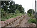
The railway to Alloa
Electrification masts have been installed but the overhead is not yet fitted.
Image: © Jonathan Thacker
Taken: 17 Aug 2018
0.07 miles
7

Cambus Iron Bridge
Cambus Iron Bridge over the River Devon. This scheduled ancient monument was constructed in the early 19th century, and is of single span pre-fabricated lattice girder construction. Extensive restoration work was carried out on the bridge in 1997.
Image: © William Starkey
Taken: 29 Aug 2011
0.11 miles
8
The railway to Stirling
Electrification masts installed but not yet the overhead.
Image: © Jonathan Thacker
Taken: 17 Aug 2018
0.12 miles
9
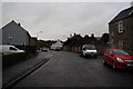
Forth Street in Cambus
Looking southward
Image: © Peter Wood
Taken: 30 Sep 2017
0.14 miles
10

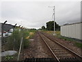
Cambus Loop
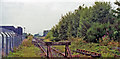
The re-opened railway line between Stirling and Alloa is used by an hourly passenger service and lengthy coal trains between Hunterston, Ayrshire, and Longannet power station, Fife, the number of the latter depending on the time of the year and electricity requirements. The line is mainly single track but there is a double-track section for about a mile north of Stirling and half-mile long loops east and west of Alloa. In this view, taken from the level crossing in Station Road, Cambus, 4½ miles from Stirling according to the yellow milepost, the start of the Cambus Loop can be seen in the distance. Its other end is marked by two red signal lights in the far distance. Trains would normally use the right-hand, straight track in both directions; the left-hand loop line would only be needed if trains had to pass one another. The gap in the fence on the right marks the former western entrance to Alloa New Yard, a relatively short-lived marshalling yard opened in the early 1960s but virtually disused by the 1980s. The timbering in the foreground is intended to prevent cats, dogs and humans straying off the road and along the railway.
Image: © A-M-Jervis
Taken: 16 Apr 2008
0.14 miles