IMAGES TAKEN NEAR TO
Bowhouse Road, ALLOA, FK10 1DA
Introduction
This page details the photographs taken nearby to Bowhouse Road, FK10 1DA by members of the Geograph project.
The Geograph project started in 2005 with the aim of publishing, organising and preserving representative images for every square kilometre of Great Britain, Ireland and the Isle of Man.

There are currently over 7.5m images from over14,400 individuals and you can help contribute to the project by visiting https://www.geograph.org.uk
Image Map
Images are licensed for reuse under creativecommons.org/licenses/by-sa/2.0
Notes
- Clicking on the map will re-center to the selected point.
- The higher the marker number, the further away the image location is from the centre of the postcode.
Image Listing (10 Images Found)
Images are licensed for reuse under creativecommons.org/licenses/by-sa/2.0
Image
Details
Distance
1
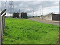
Sewage treatment works, Alloa
At Forthbank, near a recycling plant.
Image: © Richard Webb
Taken: 2 Sep 2011
0.02 miles
2
Sewage treatment works, Alloa
Sewage treatment works, Forthbank.
Image: © Richard Webb
Taken: 2 Sep 2011
0.04 miles
3
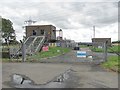
Sewage treatment works, Alloa
Near a recycling centre and road into a landfill site.
Image: © Richard Webb
Taken: 2 Sep 2011
0.05 miles
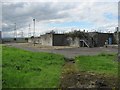
4
Recycling centre
Forthbank recycling centre in the Bowhouse area of Alloa.
Image: © Paul McIlroy
Taken: 16 Feb 2007
0.09 miles
5
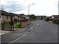
Riverside View, Alloa
No you cannot see a river, but you can certainly smell the sewage. The two bedroom house with the board was on the market for offers over £88,000.
Image: © Richard Webb
Taken: 2 Sep 2011
0.13 miles
6
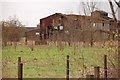
Derelict building
Derelict industrial building in the Bowhouse area of Alloa.
Image: © Paul McIlroy
Taken: 16 Feb 2007
0.13 miles
7
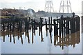
Alloa Harbour
For over two hundred years Alloa had a busy working harbour, shipping coal and salt to Scandinavia and The Low countries, but after a gradual decline it was closed down in 1960. This picture shows some of what remains.
Image: © Paul McIlroy
Taken: 2 Mar 2007
0.15 miles
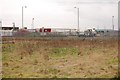
8
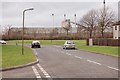
Alloa
The main employer in Alloa is United Glass, this is their plant viewed from Bowhouse Road.
Image: © Paul McIlroy
Taken: 16 Feb 2007
0.18 miles
9
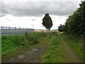
Path, Alloa
A path across marshy carse land near the Forth. Here it passes a gas valve compound.
The acronymn GVC on maps stands for Gas Valve Compound.
Image: © Richard Webb
Taken: 2 Sep 2011
0.23 miles
10

Lime Tree Walk
This is Lime Tree Walk which was created in 1714 to link Alloa Harbour to the town. The person responsible for much of the infrastructure around Alloa in the 18th century was John Erskine, 6th Earl of Mar. This view is towards the town.
Image: © Paul McIlroy
Taken: 8 Jun 2007
0.24 miles