IMAGES TAKEN NEAR TO
Marshill, ALLOA, FK10 1AB
Introduction
This page details the photographs taken nearby to Marshill, FK10 1AB by members of the Geograph project.
The Geograph project started in 2005 with the aim of publishing, organising and preserving representative images for every square kilometre of Great Britain, Ireland and the Isle of Man.

There are currently over 7.5m images from over14,400 individuals and you can help contribute to the project by visiting https://www.geograph.org.uk
Image Map
Images are licensed for reuse under creativecommons.org/licenses/by-sa/2.0
Notes
- Clicking on the map will re-center to the selected point.
- The higher the marker number, the further away the image location is from the centre of the postcode.
Image Listing (85 Images Found)
Images are licensed for reuse under creativecommons.org/licenses/by-sa/2.0
Image
Details
Distance
1
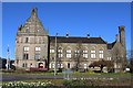
Alloa Town Hall
Category C-listed. Built 1888. Architects Alfred Waterhouse & Son.
Image: © Leslie Barrie
Taken: 18 Apr 2014
0.02 miles
2
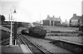
Coal train at Alloa, 1965
Standard Class 4 2-6-0 76110 has picked up a train from the marshalling yard http://www.geograph.org.uk/photo/6159311 and is proceeding east through the station.
Passenger services ceased in 1968, but the line remained open for freight. Passenger services resumed in 2008 between Stirling and Alloa, but with a new station. The new situation can be seen here https://www.geograph.org.uk/photo/1010303 - the bridge in that view is the same as this one.
Image: © Alan Murray-Rust
Taken: Unknown
0.06 miles
3
Ochil House, Mars Hill, former drill hall
Image: © Alex McGregor
Taken: 1 Jul 2014
0.07 miles
4

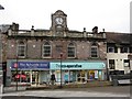
Co-operative Building, Drysdale Street, Alloa
Dated 1912
Image: © Leslie Barrie
Taken: 18 Apr 2014
0.10 miles
5
Site of Alloa station, 1991
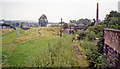
View eastward, towards Kinross Junction, Thornton Junction via Oakley and Dunfermline Upper also via Culross and Dunfermline Lower, these being ex-NBR routes from Stirling, also ex-Caledonian services came from Larbert. This important junction station was closed on 7/10/68 - for goods not until 13/7/74, but happily this scene of desolation has passed, for a substantial new station was opened on 19/5/08, with a passenger service from Glasgow via Stirling over a line still kept open for coal traffic to Longannet Power Station on the Kincardine line - the half-rusted track seen here on the right. (See Image] by A.M. Jervis). Alloa station had lost its passenger services gradually: Dunfermline via Culross 7/7/30, Kinross Junction 15/6/64, Larbert 29/1/68, Stirling - Alloa - Oakley - Dunfermline 7/10/68.
Image: © Ben Brooksbank
Taken: 5 Sep 1991
0.12 miles
6

Alloa's new railway
Taken from Erskine Street bridge, this shows the re-laid single line railway from Stirling curving round the leisure centre that was built on the old station site. On the left is the town centre bypass road and the fairly modern police station built on the site of an earlier bus station.
Image: © A-M-Jervis
Taken: 16 Apr 2008
0.12 miles
7
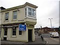
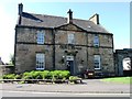
Station Bar
Situated where Primrose Street meets the ring road.
Image: © Richard Webb
Taken: 28 Feb 2012
0.13 miles
9
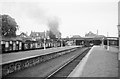
Coal train at Alloa, 1965
Standard Class 4 2-6-0 75110 has picked up a train from the marshalling yard http://www.geograph.org.uk/photo/6159311 and is proceeding east through the station. The bay platforms of the station are a reminder of the branch lines to Alva and Larbert which had already closed for passengers. Alloa would lose its passenger service in 1968.
The site of the station is now occupied by a leisure centre, with just a single track remaining on the far right hand side of the picture. When a passenger service to Stirling was reinstated in 2008 a new station was built to the east.
Image: © Alan Murray-Rust
Taken: Unknown
0.14 miles