IMAGES TAKEN NEAR TO
Mansfield Terrace, BUDLEIGH SALTERTON, EX9 6EN
Introduction
This page details the photographs taken nearby to Mansfield Terrace, EX9 6EN by members of the Geograph project.
The Geograph project started in 2005 with the aim of publishing, organising and preserving representative images for every square kilometre of Great Britain, Ireland and the Isle of Man.

There are currently over 7.5m images from over14,400 individuals and you can help contribute to the project by visiting https://www.geograph.org.uk
Image Map
Images are licensed for reuse under creativecommons.org/licenses/by-sa/2.0
Notes
- Clicking on the map will re-center to the selected point.
- The higher the marker number, the further away the image location is from the centre of the postcode.
Image Listing (35 Images Found)
Images are licensed for reuse under creativecommons.org/licenses/by-sa/2.0
Image
Details
Distance
1

Mansfield Terrace, Budleigh Salterton
This short road runs underneath the former railway line; the picture was taken from the bridge parapet
Image: © David Smith
Taken: 12 Aug 2019
0.07 miles
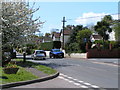
3

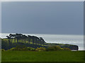
Entering Budleigh Salterton
On the A3178 East Budleigh Road
Image: © Anthony Vosper
Taken: 29 Feb 2012
0.11 miles
4
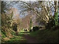
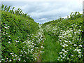
Former railway line, Budleigh Salterton
Providing a useful footpath between Upper Stoneborough Lane and East Budleigh Road, although it's not shown as such on the maps. This runs between properties on Honey Park Road (left) and East Budleigh Road.
Image: © Derek Harper
Taken: 21 Jan 2012
0.11 miles
5
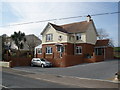
Ashbury Dental Surgery, on East Budleigh Road
Image: © Roger Cornfoot
Taken: 26 Feb 2009
0.12 miles
6

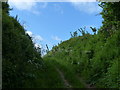
Former railway line, Budleigh Salterton
From the start of the path running along the dismantled line near East Budleigh Road.
Image: © Derek Harper
Taken: 21 Jan 2012
0.12 miles
8
East Budleigh road, entering Budleigh Salterton
WF02 WEC driving into Budleigh Salterton, D9 PXO parked
Image: © Rob Purvis
Taken: 25 Apr 2009
0.14 miles
9

Footpath steps at Kersbrook
This gives you access from the road onto the course of the old branch line railway that ran into Budleigh Salterton.
Image: © Anthony Vosper
Taken: 29 Feb 2012
0.14 miles