IMAGES TAKEN NEAR TO
Penlee, BUDLEIGH SALTERTON, EX9 6BP
Introduction
This page details the photographs taken nearby to Penlee, EX9 6BP by members of the Geograph project.
The Geograph project started in 2005 with the aim of publishing, organising and preserving representative images for every square kilometre of Great Britain, Ireland and the Isle of Man.

There are currently over 7.5m images from over14,400 individuals and you can help contribute to the project by visiting https://www.geograph.org.uk
Image Map
Images are licensed for reuse under creativecommons.org/licenses/by-sa/2.0
Notes
- Clicking on the map will re-center to the selected point.
- The higher the marker number, the further away the image location is from the centre of the postcode.
Image Listing (187 Images Found)
Images are licensed for reuse under creativecommons.org/licenses/by-sa/2.0
Image
Details
Distance
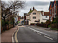
1
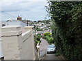
Looking North towards Victoria Place
Victoria Place becomes a footpath joining the South West Coast Path.
Image: © William Fairbrother
Taken: 16 Aug 2014
0.04 miles
2
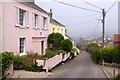
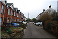
Victorian houses, Victoria Place, Budleigh Salterton
Victoria Place is a hill which drops from the coast to West Hill, Budleigh Salterton close to the start of High Street. These houses retain brick walls at the front of their gardens
Image: © David Smith
Taken: 25 Jun 2015
0.05 miles
3
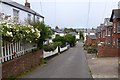
The foot of Victoria Place
Victoria Place is a hill which drops from the coast to West Hill, Budleigh Salterton close to the start of High Street. Some houses offer bed and breakfast and there is a residential care home
Image: © David Smith
Taken: 25 Jun 2015
0.05 miles
4
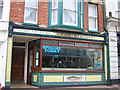
G & K Sanders, fishmongers, High Street, Budleigh Salterton
Image: © Christopher Hilton
Taken: 23 Apr 2005
0.06 miles
5
Descending into Budleigh Salterton
On West Hill.
Image: © John Lucas
Taken: 20 Feb 2024
0.06 miles
6
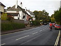
Bus stop on Westhill
Note the postman on his bike, perhaps something to become a thing of the past.
Image: © Anthony Vosper
Taken: 28 Oct 2010
0.06 miles
7
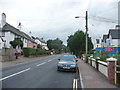
Budleigh Salterton : West Hill Road, B3178
Image: © Lewis Clarke
Taken: 6 Sep 2009
0.07 miles
8
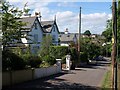
Westbourne Terrace, Budleigh Salterton
A steep road of large semi-detached houses, leading down from Jubilee Park to West Hill.
Image: © Derek Harper
Taken: 9 Jul 2010
0.07 miles
10
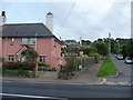
Budleigh Salterton : Westbourne Terrace & Pink House
Image: © Lewis Clarke
Taken: 6 Sep 2009
0.08 miles