IMAGES TAKEN NEAR TO
Underhill Crescent, EXMOUTH, EX8 5JF
Introduction
This page details the photographs taken nearby to Underhill Crescent, EX8 5JF by members of the Geograph project.
The Geograph project started in 2005 with the aim of publishing, organising and preserving representative images for every square kilometre of Great Britain, Ireland and the Isle of Man.

There are currently over 7.5m images from over14,400 individuals and you can help contribute to the project by visiting https://www.geograph.org.uk
Image Map
Images are licensed for reuse under creativecommons.org/licenses/by-sa/2.0
Notes
- Clicking on the map will re-center to the selected point.
- The higher the marker number, the further away the image location is from the centre of the postcode.
Image Listing (321 Images Found)
Images are licensed for reuse under creativecommons.org/licenses/by-sa/2.0
Image
Details
Distance

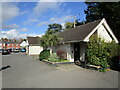
4
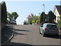
Lympstone : Underhill Crescent
Underhill Crescent heading off from Underhill.
Image: © Lewis Clarke
Taken: 22 Oct 2013
0.05 miles
5
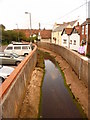
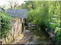
Lympstone: Wotton Brook in culvert
The stream is led through this concrete channel between the main village car park and the back gardens of properties in The Strand inland of the railway.
Image: © Chris Downer
Taken: 29 Aug 2009
0.07 miles

8
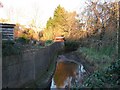
Stream running through Lympstone
This stream backs up at high tide and is prone to flooding.
Image: © David Smith
Taken: 29 Jan 2006
0.08 miles
9

An old advertisement painted on a wall in Lympstone
Image: © David Smith
Taken: 4 Apr 2010
0.08 miles